.svg)
File:IndoGangeticPlain Map.png

Size of this preview: 220 × 147 pixels. Other resolutions: 320 × 214 pixels | 433 × 290 pixels.
Original file (433 × 290 pixels, file size: 27 KB, MIME type: image/png)
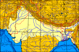
Map of the Indo-Gangetic Plain.
| I, the copyright holder of this work, release this work into the public domain. This applies worldwide. In some countries this may not be legally possible; if so: I grant anyone the right to use this work for any purpose, without any conditions, unless such conditions are required by law. |
I produced this map myself using the program here archive copy at the Wayback Machine and modifying it. It remains in the public domain. The map is an azimuthal equal-area projection. The Line of Control through Kashmir is green. Where the line of control along the Indo-Chinese frontier coincides with one side's territorial claims, the line is pink; borders claimed but not controlled are purple. Non-disputed boudaries are in red. QuartierLatin1968 01:36, 21 May 2005 (UTC)
File history
Click on a date/time to view the file as it appeared at that time.
| Date/Time | Thumbnail | Dimensions | User | Comment | |
|---|---|---|---|---|---|
| current | 07:06, 21 May 2005 | | 433 × 290 (27 KB) | wikimediacommons>QuartierLatin1968 | Map of the Indo-Gangetic Plain. {{PD}} I produced this map myself using the program [http://www.aquarius.geomar.de/omc/make_map.html here] and modifying it. It remains in the public domain. The map is an azimuthal equal-area projection. The Line of Contr |
File usage
The following 4 pages use this file: