
File:Indians NW of South Carolina.jpg

Original file (1,770 × 1,217 pixels, file size: 294 KB, MIME type: image/jpeg)
Summary
| DescriptionIndians NW of South Carolina.jpg |
English: "Map of the Several Nations of Indians to the Northwest of South Carolina" or the "Catawba Deerskin Map", an annotated copy of hand-painted deerskin original made by a Catawba chieftain to Governor Francis Nicholson "This map describing the scituation [sic] of the several nations of Indians to the NW of South Carolina was coppyed [sic] from a draught [sic] drawn & painted on a deer skin by an Indian Cacique and presented to Francis Nicholason Esqr. Governor of South Carolina by whom it is most humbly dedicated to his Royal Highness George, Prince of Wales." |
||
| Date |
circa 1724 date QS:P,+1724-00-00T00:00:00Z/9,P1480,Q5727902 |
||
| Source |
|
||
| Author | Unknown authorUnknown author | ||
| Other versions |
|


Licensing
|
This is a faithful photographic reproduction of a two-dimensional, public domain work of art. The work of art itself is in the public domain for the following reason:
The official position taken by the Wikimedia Foundation is that "faithful reproductions of two-dimensional public domain works of art are public domain".
This photographic reproduction is therefore also considered to be in the public domain in the United States. In other jurisdictions, re-use of this content may be restricted; see Reuse of PD-Art photographs for details. | |||||


| Annotations InfoField | This image is annotated: View the annotations at Commons |

Charlestown [i.e., Charleston]
This Map describing the Scituation of the Several Nations
of Indians to the NW. of South Carolina was coppyed
from a Draught drawn & painted on a Deer Skin by an Indian
Cacique and presented to Francis Nicholson Esqr. Governour of
South Carolina by whom it is most humbly Dedicated
To His Royal Highness George Prince of Wales
Virginie [i.e., Virginia]
Succa
Nasaw [i.e., Catawba]
Chickisa [i.e., Chickasaw]
Cherrikies [i.e., Cherokee]
The English path to Nasaw [i.e., the Catawba]
An Indian
a Hunting
Waterie [i.e., Wateree]
Wasinisa
Casuie
Nustie
Wiapie [Pee Dee?]
Youchine [i.e., Yuchi]
Charra [i.e., Cheraw]
Suttirie [i.e., Suteree]
Saxippaha [i.e., Sissipahaw]
B[ritish]M[useum] Add[itional]. M[anu]S[cripts]. 4723
Division of Maps
FEB 18 1929
Library of Congress
ICH DIEN
Captions
File history
Click on a date/time to view the file as it appeared at that time.
| Date/Time | Thumbnail | Dimensions | User | Comment | |
|---|---|---|---|---|---|
| current | 13:26, 9 October 2016 | 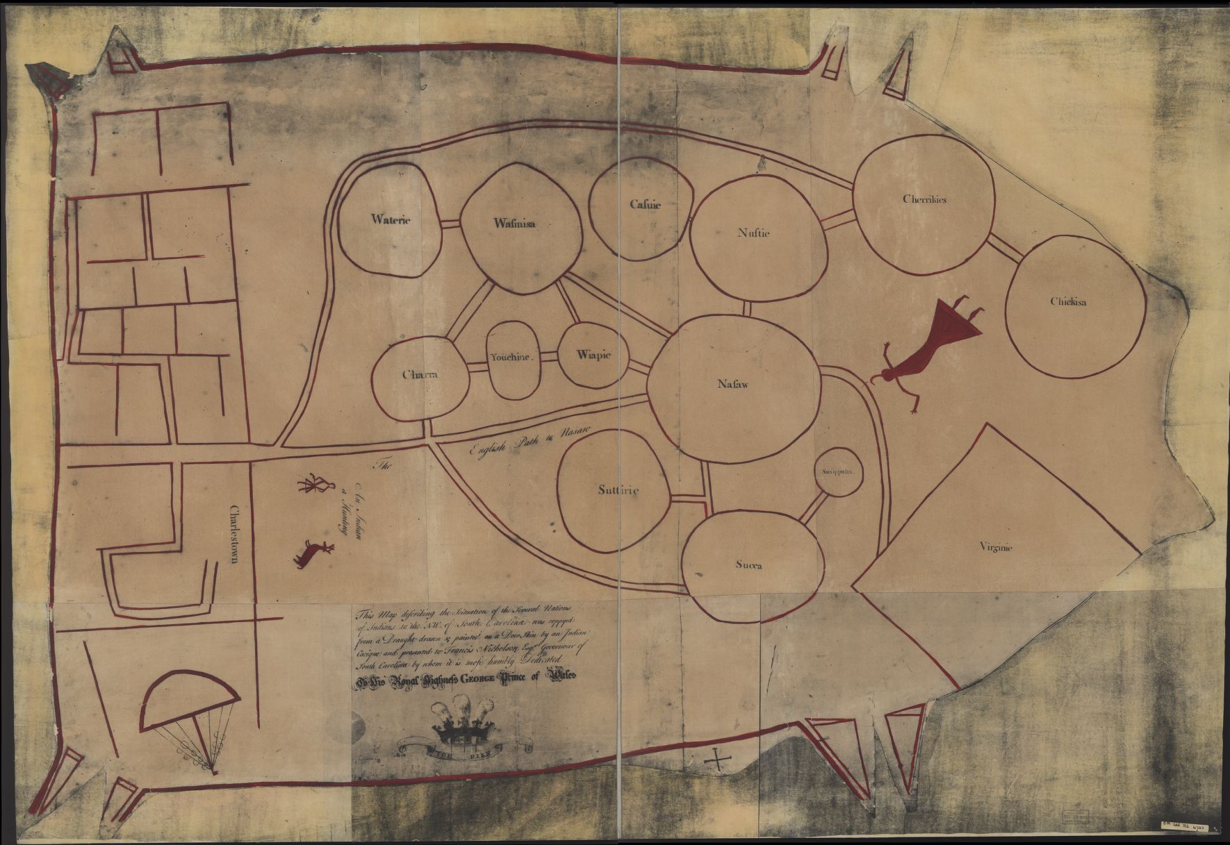 | 1,770 × 1,217 (294 KB) | (username removed) |
File usage
The following page uses this file:
