.svg)
File:Himalayas landsat 7.png

Size of this preview: 220 × 135 pixels. Other resolutions: 320 × 197 pixels | 500 × 308 pixels | 990 × 609 pixels.
Original file (990 × 609 pixels, file size: 1.17 MB, MIME type: image/png)
Summary
| Description |
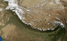
Himalayas as pictured by NASA Landsat 7 Satellite. Other Versions: thumb|120px|left|Added Territorial Boundaries |
| Source | Satellite imagery taken from NASA World Wind software (by screenshot) |
| Author | Photograph: NASA |
Licensing
| This image is in the public domain because it is a screenshot from NASA’s globe software World Wind using a public domain layer, such as Blue Marble, MODIS, Landsat, SRTM, USGS or GLOBE.
|
 |
Original upload log
The original description page was here. All following user names refer to en.wikipedia.
| Date/Time | Dimensions | User | Comment |
|---|---|---|---|
| 2011-03-22 16:58:29 | 990× 609× | Tatiraju.rishabh | Himalayas as pictured by NASA Landsat 7 Satellite. |
File history
Click on a date/time to view the file as it appeared at that time.
| Date/Time | Thumbnail | Dimensions | User | Comment | |
|---|---|---|---|---|---|
| current | 12:01, 21 July 2016 | | 990 × 609 (1.17 MB) | wikimediacommons>FastilyClone | Transferred from en.wikipedia (MTC!) |
File usage
The following page uses this file: