
File:Gujarat Talukas Map 2011.svg

Original file (SVG file, nominally 3,502 × 2,514 pixels, file size: 1.98 MB)
 ✓
The source code of this SVG is valid.
✓
The source code of this SVG is valid.
Summary
| Description |
English: Administrative map of Gujarat with the administrative divisions since August 15, 2011 |
|---|---|
| Source |
Own work using page 17 map of Geographical Indications Journal of India [1] |
| Date |
see file history |
| Author | |
| Permission (Reusing this file) |
I, the copyright holder of this work, hereby publish it under the following licenses:  Permission is granted to copy, distribute and/or modify this document under the terms of the GNU Free Documentation License, Version 1.2 or any later version published by the Free Software Foundation; with no Invariant Sections, no Front-Cover Texts, and no Back-Cover Texts.
GFDL GNU Free Documentation License //en.wikipedia.org/wiki/Wikipedia:Text_of_the_GNU_Free_Documentation_License true true    This work is licensed under the Creative Commons Attribution-ShareAlike 3.0 License. https://creativecommons.org/licenses/by-sa/3.0/CC-BY-SA-3.0Creative Commons Attribution-ShareAlike 3.0truetrue You may select the license of your choice.
|
Licensing

Following the mandate of the National Data Sharing and Accessibility Policy (NDSAP) of Government of India that applies to all shareable non-sensitive data available either in digital or analog forms but generated using public funds by various agencies of the Government of India, all users are provided a worldwide, royalty-free, non-exclusive license to use, adapt, publish (either in original, or in adapted and/or derivative forms), translate, display, add value, and create derivative works (including products and services), for all lawful commercial and non-commercial purposes, and for the duration of existence of such rights over the data or information.
The user must acknowledge the provider, source, and license of data by explicitly publishing the attribution statement, including the DOI (Digital Object Identifier), or the URL (Uniform Resource Locator), or the URI (Uniform Resource Identifier) of the data concerned.
The user must not indicate or suggest in any manner that the data provider(s) endorses their use and/or the user. The data provider(s) are not liable for any errors or omissions, and will not under any circumstances be liable for any loss, injury or damage caused by its use.
The data provider(s) do not guarantee the continued supply of updated or up-to-date versions of the data, and will not be held liable in case the continued supply of updated data is not provided.
Exemptions: The license does not cover the following kinds of data: a. personal information; b. data that is non-shareable and/or sensitive; c. names, crests, logos and other official symbols of the data provider(s); d. data subject to other intellectual property rights, including patents, trade-marks and official marks; e. military insignia; f. identity documents; and g. any data that should not have been publicly disclosed for the grounds provided under section 8 of the Right to Information Act, 2005. https://data.gov.in/sites/default/files/Gazette_Notification_OGDL.pdf GODL-India Government Open Data License – India true
true
-
 since August 15, 2013
 -
 since August 15, 2013 (coloured and named)
 -
 since August 15, 2013 (gujarati coloured and named)
 -
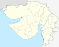 until August 15, 2013


.svg)


- ^ "Geographical Indications Journal of India" (PDF). ipindia.gov.in.
File history
Click on a date/time to view the file as it appeared at that time.
| Date/Time | Thumbnail | Dimensions | User | Comment | |
|---|---|---|---|---|---|
| current | 19:02, 25 March 2023 |  | 3,502 × 2,514 (1.98 MB) | smartcommons-wikipedia-en>DSP2092 | Reverted to version as of 09:46, 25 March 2023 (UTC) |
File usage
There are no pages that use this file.
