File:Gilgit Baltistan Location Map.svg

From Bharatpedia, an open encyclopedia

Original file(SVG file, nominally 1,720 × 1,300 pixels, file size: 276 KB)

This file is from Wikimedia Commons and may be used by other projects. The description on its file description page there is shown below.

The boundaries on this map show the de facto situation. This is just one of several different views on the subject (see COM:NPOV).

Summary

Description
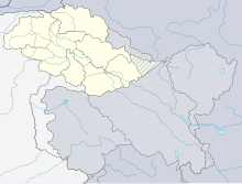
Deutsch: Positionskarte von Gilgit Baltistan. De-facto-Situation.

Quadratische Plattkarte, N-S-Streckung 120 %. Geographische Begrenzung der Karte:

  • N: 37.2° N
  • S: 32.1° N
  • W: 72.4° O
  • O: 80.5° O
English: Location map of Gilgit Baltistan. De facto situation.

Equirectangular projection, N/S stretching 120 %. Geographic limits of the map:

  • N: 37.2° N
  • S: 32.1° N
  • W: 72.4° E
  • E: 80.5° E
Date
Source

using

  • United States National Imagery and Mapping Agency data
  • World Data Base II data
Author RaviC, based on File:India Jammu and Kashmir location map.svg by NordNordWest
Permission
(Reusing this file)

I have published this file as author NordNordWest under the "CC-BY-SA-3.0-DE" in Wikipedia. This means that free, commercial usage outside of Wikipedia is permitted under the following licence terms:

Please send me a specimen copy or the URL of the website where the file is used.

Please write an email to nnwest[at]web.de if you

  • need my postal address for sending a specimen copy
  • have further questions about the terms of the licence

PS: In case of refusal of the above terms the author reserves the right to take legal action.

w:en:Creative Commons
attribution share alike
This file is licensed under the Creative Commons Attribution-Share Alike 3.0 Germany license.
You are free:
  • to share – to copy, distribute and transmit the work
  • to remix – to adapt the work
Under the following conditions:
  • attribution – You must give appropriate credit, provide a link to the license, and indicate if changes were made. You may do so in any reasonable manner, but not in any way that suggests the licensor endorses you or your use.
  • share alike – If you remix, transform, or build upon the material, you must distribute your contributions under the same or compatible license as the original.
Other versions

Derivative works of this file:

Kartenwerkstatt
This map has been made or improved in the German Kartenwerkstatt (Map Lab). You can propose maps to improve as well.

Captions

Add a one-line explanation of what this file represents

Items portrayed in this file

depicts

15 April 2010

image/svg+xml

File history

Click on a date/time to view the file as it appeared at that time.

Date/TimeThumbnailDimensionsUserComment
current21:44, 24 October 2020Thumbnail for version as of 21:44, 24 October 20201,720 × 1,300 (276 KB)wikimediacommons>C1MMRemoved intersections

The following page uses this file:

Metadata