File:Firoze Minar at Gaur in Malda district 10.jpg
Original file (5,699 × 3,804 pixels, file size: 25.35 MB, MIME type: image/jpeg)
This file is from Wikimedia Commons and may be used by other projects. The description on its file description page there is shown below.
Summary
DescriptionFiroze Minar at Gaur in Malda district 10.jpg |
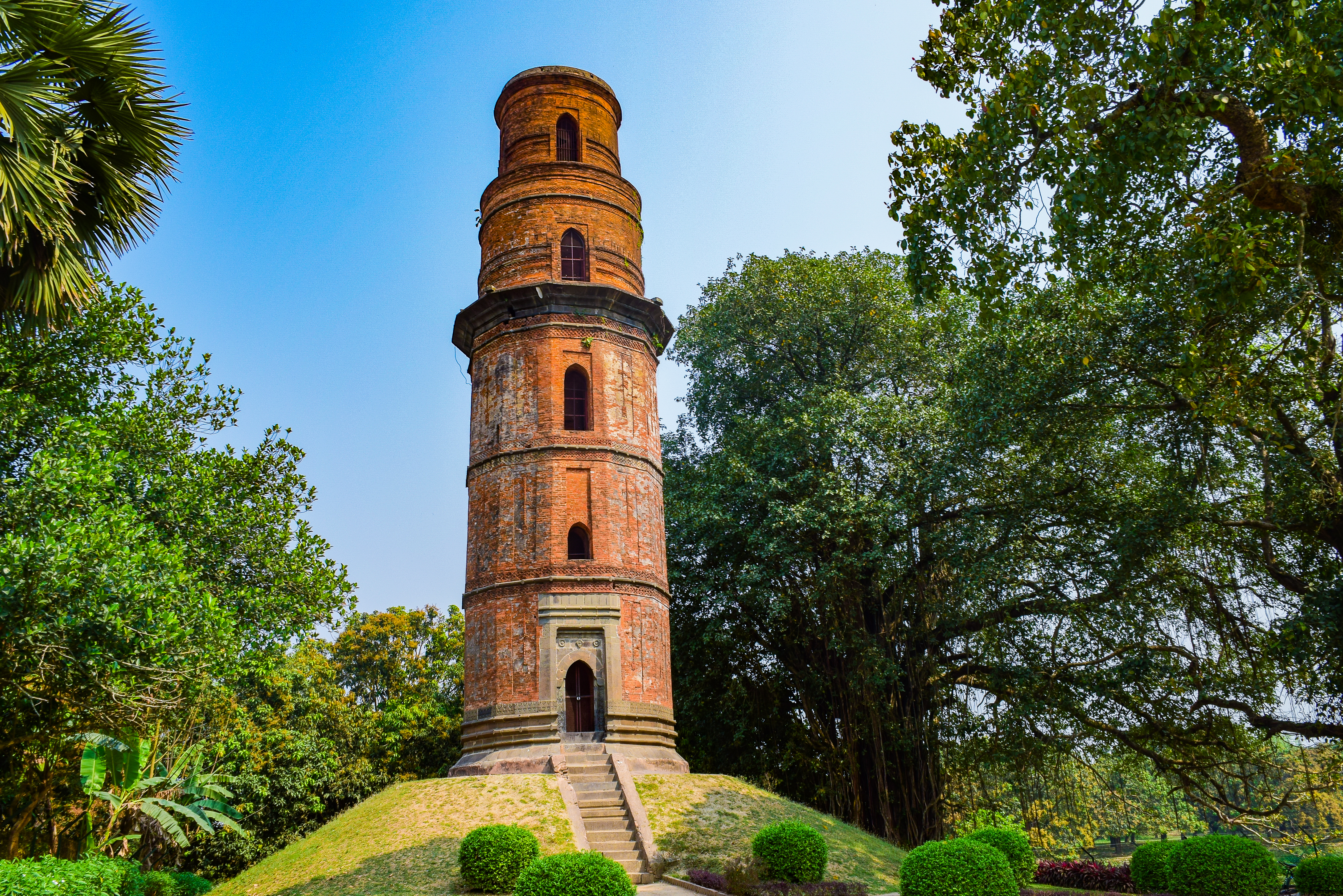
English: Built between 1486-89 by Saifuddin Firoze, Firoze Minar is a 25.60 metres high tower with spiral staircase. Saifuddin Firoze was an Abyssinian who became Sultan by killing Barbak Shah. |
Date | |
Source | Own work |
Author | Amitabha Gupta |
Camera location | 24° 52′ 23.65″ N, 88° 07′ 47.98″ E | View this and other nearby images on: OpenStreetMap | 24.873235; 88.129995 |
---|
Licensing
- You are free:
- to share – to copy, distribute and transmit the work
- to remix – to adapt the work
- Under the following conditions:
- attribution – You must give appropriate credit, provide a link to the license, and indicate if changes were made. You may do so in any reasonable manner, but not in any way that suggests the licensor endorses you or your use.
This file was uploaded as part of Wiki Explores Malda - Phase I under Wiki Exploration Program, an initiative by West Bengal Wikimedians User Group.
|
The production, editing or release of this file was supported by the West Bengal Wikimedians User Group.
To see other files made with the support of the user group, please check the category Supported by West Bengal Wikimedians User Group. English | Français | македонски | Українська | +/−
|
This image has been assessed using the Quality image guidelines and is considered a Quality image.
العربية ∙ جازايرية ∙ беларуская ∙ беларуская (тарашкевіца) ∙ български ∙ বাংলা ∙ català ∙ čeština ∙ Cymraeg ∙ Deutsch ∙ Schweizer Hochdeutsch ∙ Zazaki ∙ Ελληνικά ∙ English ∙ Esperanto ∙ español ∙ eesti ∙ euskara ∙ فارسی ∙ suomi ∙ français ∙ galego ∙ עברית ∙ हिन्दी ∙ hrvatski ∙ magyar ∙ հայերեն ∙ Bahasa Indonesia ∙ italiano ∙ 日本語 ∙ Jawa ∙ ქართული ∙ 한국어 ∙ kurdî ∙ Lëtzebuergesch ∙ lietuvių ∙ македонски ∙ മലയാളം ∙ मराठी ∙ Bahasa Melayu ∙ Nederlands ∙ Norfuk / Pitkern ∙ polski ∙ português ∙ português do Brasil ∙ rumantsch ∙ română ∙ русский ∙ sicilianu ∙ slovenčina ∙ slovenščina ∙ shqip ∙ српски / srpski ∙ svenska ∙ தமிழ் ∙ తెలుగు ∙ ไทย ∙ Tagalog ∙ Türkçe ∙ toki pona ∙ українська ∙ vèneto ∙ Tiếng Việt ∙ 中文 ∙ 中文(简体) ∙ 中文(繁體) ∙ +/− |
This image was selected as picture of the day on Bengali Wikipedia.
|
Items portrayed in this file
depicts
24°52'23.646"N, 88°7'47.982"E
16 March 2018
0.005 second
18 millimetre
125
image/jpeg
File history
Click on a date/time to view the file as it appeared at that time.
Date/Time | Thumbnail | Dimensions | User | Comment | |
---|---|---|---|---|---|
current | 13:17, 12 July 2021 | 5,699 × 3,804 (25.35 MB) | wikimediacommons>Asmitghosh3 | Color edit |
File usage
The following 2 pages use this file:
Metadata
This file contains additional information, probably added from the digital camera or scanner used to create or digitize it.
If the file has been modified from its original state, some details may not fully reflect the modified file.
Camera manufacturer | NIKON CORPORATION |
---|---|
Camera model | NIKON D5300 |
Exposure time | 1/200 sec (0.005) |
F Number | f/8 |
ISO speed rating | 125 |
Date and time of data generation | 09:48, 16 March 2018 |
Lens focal length | 18 mm |
Latitude | 24° 52′ 23.65″ N |
Longitude | 88° 7′ 47.98″ E |
Altitude | 43 meters below sea level |
Horizontal resolution | 72 dpi |
Vertical resolution | 72 dpi |
Software used | Adobe Photoshop Express Windows 10 (Windows) |
File change date and time | 13:15, 12 July 2021 |
Exposure Program | Manual |
Exif version | 2.3 |
Date and time of digitizing | 09:48, 16 March 2018 |
APEX shutter speed | 7.643856 |
APEX aperture | 6 |
APEX exposure bias | 0 |
Maximum land aperture | 3.6 APEX (f/3.48) |
Metering mode | Pattern |
Light source | Unknown |
Flash | Flash did not fire |
User comments | COPYRIGHT-AMITABHA GUPTA |
DateTimeOriginal subseconds | 70 |
DateTimeDigitized subseconds | 70 |
Color space | sRGB |
Sensing method | One-chip color area sensor |
File source | Digital still camera |
Scene type | A directly photographed image |
Custom image processing | Normal process |
Exposure mode | Manual exposure |
White balance | Auto white balance |
Digital zoom ratio | 1 |
Focal length in 35 mm film | 27 mm |
Scene capture type | Standard |
Scene control | None |
Contrast | Normal |
Saturation | Normal |
Sharpness | Normal |
Subject distance range | Unknown |
GPS time (atomic clock) | 04:18:32.15 |
Satellites used for measurement | 06 |
Geodetic survey data used | WGS-84 |
GPS date | 16 March 2018 |
GPS tag version | 0.0.3.2 |
Serial number of camera | 7316637 |
Lens used | 18.0-140.0 mm f/3.5-5.6 |
Date metadata was last modified | 18:45, 12 July 2021 |
Unique ID of original document | xmp.did:444620aa-eb79-654b-9275-51807ec29905 |
IIM version | 4 |