.svg)
File:Federation of Rhodesia and Nyasaland.png

Size of this preview: 220 × 220 pixels. Other resolution: 300 × 300 pixels.
Original file (300 × 300 pixels, file size: 11 KB, MIME type: image/png)
Summary

|
This locator map image could be re-created using vector graphics as an SVG file. This has several advantages; see Commons:Media for cleanup for more information. If an SVG form of this image is available, please upload it and afterwards replace this template with
{{vector version available|new image name}}.
It is recommended to name the SVG file “Federation of Rhodesia and Nyasaland.svg”—then the template Vector version available (or Vva) does not need the new image name parameter. |
| Description |
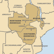
English: Map of the Federation of Rhodesia and Nyasaland.
Own work. Link to user page as attribution. |
| Date | 18 May 2007 (original upload date) |
| Source | Geography depicted confirmed by map on inside cover of Wood, J R T (1983). The Welensky Papers: A History of the Federation of Rhodesia and Nyasaland. Durban: Graham Publishing. ISBN 0-620-06410-2 |
| Author | The original uploader was Beneaththelandslide at English Wikipedia. |
Licensing
This file is licensed under the Creative Commons Attribution 2.5 Generic license.
- You are free:
- to share – to copy, distribute and transmit the work
- to remix – to adapt the work
- Under the following conditions:
- attribution – You must give appropriate credit, provide a link to the license, and indicate if changes were made. You may do so in any reasonable manner, but not in any way that suggests the licensor endorses you or your use.
Original upload log
The original description page was here. All following user names refer to en.wikipedia.
- 2007-05-18 02:53 Beneaththelandslide 300×300× (11026 bytes) Map of the [[Federation of Rhodesia an Nyasaland]]. Own work. Link to [[User:Beneaththelandslide|user page]] as attribution.
File history
Click on a date/time to view the file as it appeared at that time.
| Date/Time | Thumbnail | Dimensions | User | Comment | |
|---|---|---|---|---|---|
| current | 10:40, 4 June 2010 | | 300 × 300 (11 KB) | wikimediacommons>File Upload Bot (Magnus Manske) | {{BotMoveToCommons|en.wikipedia|year={{subst:CURRENTYEAR}}|month={{subst:CURRENTMONTHNAME}}|day={{subst:CURRENTDAY}}}} {{Information |Description={{en|Map of the en:Federation of Rhodesia and Nyasaland. Own work. Link to [[:en:User:Beneaththelands |
File usage
The following page uses this file: