


File:Extent of territorial control in sri lanka.png

Size of this preview: 206 × 329 pixels. Other resolutions: 150 × 240 pixels | 601 × 960 pixels.
Original file (601 × 960 pixels, file size: 243 KB, MIME type: image/png)

Summary

|
This military map image could be re-created using vector graphics as a SVG file. This has several advantages; see Commons:Media for cleanup for more information. If a SVG form of this image is available, please upload it and afterwards replace this template with
{{vector version available|new image name}}.It is recommended to name the SVG file “Extent of territorial control in sri lanka.svg”—then the template Vector version available (or Vva) does not need the new image name parameter. |
Licensing

|
Permission is granted to copy, distribute and/or modify this document under the terms of the GNU Free Documentation License, Version 1.2 or any later version published by the Free Software Foundation; with no Invariant Sections, no Front-Cover Texts, and no Back-Cover Texts. A copy of the license is included in the section entitled GNU Free Documentation License.http://www.gnu.org/copyleft/fdl.htmlGFDLGNU Free Documentation Licensetruetrue |
  
|
This file is licensed under the Creative Commons Attribution-Share Alike 3.0 Unported license. | |
| ||
| This licensing tag was added to this file as part of the GFDL licensing update.http://creativecommons.org/licenses/by-sa/3.0/CC BY-SA 3.0Creative Commons Attribution-Share Alike 3.0truetrue |
According to the creator, the source was a humanitarian aid decision by the EU (reference no. ECHO/-SA/BUD/2005/02000, available online at http://ec.europa.eu/echo/pdf_files/decisions/2005/dec_sa_02000.pdf).
Captions
Add a one-line explanation of what this file represents
File history
Click on a date/time to view the file as it appeared at that time.
| Date/Time | Thumbnail | Dimensions | User | Comment | |
|---|---|---|---|---|---|
| current | 03:49, 29 December 2005 | 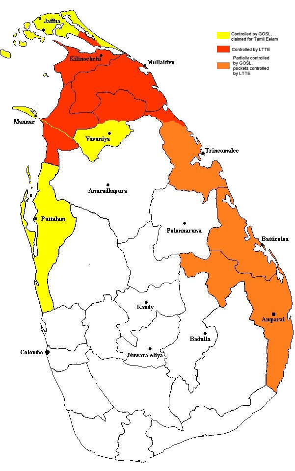 | 601 × 960 (243 KB) | smartcommons>Vadakkan | This map approximately shows the areas of Sri Lanka controlled by the LTTE and the Government, as of December 2005. The information as to areas of control was taken from a report issued by the European Union. The map was originally uploaded to :en by [[:e |
File usage
There are no pages that use this file.
