.svg)
File:Europe ISO 3166-1.svg

Size of this PNG preview of this SVG file: 220 × 161 pixels. Other resolutions: 320 × 234 pixels | 500 × 366 pixels | 700 × 512 pixels.
Original file (SVG file, nominally 700 × 512 pixels, file size: 291 KB)
Summary
| Description |
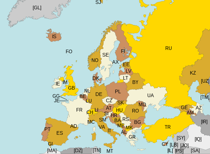
Map of Europe, with ISO 3166-1 pt · en country and territory codes. SVG format. Map legend in Portuguese and English, with name of sovereign state given in parenthesis, where applicable:
Non-European countries and territories featured in map:
|
| Date | |
| Source | Own work |
| Author | Júlio Reis |
| Other versions | Without country codes: Europe countries.svg · Only continent boundaries: Europe continents.svg · Country names in Italian: Europa-it-politica-names-big.svg · Including Kosovo: Europe ISO 3166-1 (with Kosovo).svg |
| SVG development |
.svg)
Licensing
This file is licensed under the Creative Commons Attribution-Share Alike 3.0 Unported license.
- You are free:
- to share – to copy, distribute and transmit the work
- to remix – to adapt the work
- Under the following conditions:
- attribution – You must give appropriate credit, provide a link to the license, and indicate if changes were made. You may do so in any reasonable manner, but not in any way that suggests the licensor endorses you or your use.
- share alike – If you remix, transform, or build upon the material, you must distribute your contributions under the same or compatible license as the original.
File history
Click on a date/time to view the file as it appeared at that time.
| Date/Time | Thumbnail | Dimensions | User | Comment | |
|---|---|---|---|---|---|
| current | 14:13, 28 January 2025 | | 700 × 512 (291 KB) | wikimediacommons>Carnby | SVG |
File usage
The following page uses this file: