.svg)
File:Egypt-region-map-cities-2.gif

Size of this preview: 220 × 265 pixels. Other resolution: 310 × 373 pixels.
Original file (310 × 373 pixels, file size: 14 KB, MIME type: image/gif)

|
This locator map image could be re-created using vector graphics as an SVG file. This has several advantages; see Commons:Media for cleanup for more information. If an SVG form of this image is available, please upload it and afterwards replace this template with
{{vector version available|new image name}}.
It is recommended to name the SVG file “Egypt-region-map-cities-2.svg”—then the template Vector version available (or Vva) does not need the new image name parameter. |
Summary
| Description |
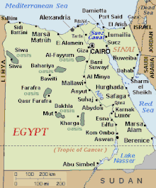
English: Regional map of Egypt, with main cities and oasis areas labeled, plus scale of miles/km (approximate). The file is in GIF format, 10x times faster than PNG format, for rapid display and to allow precise edits when adding other towns in the future.
Re-labeled to include 6 oasis areas, with "Giza" and sea-side towns, plus dotted line for Tropic of Cancer. |
| Source |
This file was created by hand-editing as a simple map of Egypt, adding towns as referenced in articles, so the locations of towns are approximate. Source: hand-edited file using en:MS Paint. |
| Author | Original CIA |
| Other versions |
|


Warning
This hand-edited map was overlaid with an unsourced map of Egypt, apparently commercial quality:
- :* on 19May07 to 10July07 (52 days);
- on 25July07 (5 hours).
The overlaid map omitted many towns, temples, and all oasis areas.
Sanity check: The current map should mirror CIA map en:Image:Eg-map.png, with similar coloring.
References
- Reference map for names (not the image): http://www.eyehouse.dk/images/map_egypt.gif archive copy at the Wayback Machine.
- Reference map for temple locations: http://unimaps.com/egypt/index.html.
Licensing
| I, the copyright holder of this work, release this work into the public domain. This applies worldwide. In some countries this may not be legally possible; if so: I grant anyone the right to use this work for any purpose, without any conditions, unless such conditions are required by law. |
Original upload log
The original description page was here. All following user names refer to en.wikipedia.
| Upload date | User | Bytes | Dimensions | Comment |
|---|---|---|---|---|
| 2008-01-13 18:27:56 | Egyegy | 14045 | 310×375 | Reverted to version as of 03:00, 12 January 2008 rv new map is an eyesore |
| 2008-01-13 17:55:31 | Arab League | 8745 | 320×373 | Reverted to version as of 20:19, 10 January 2008, reverted to simpler map due to "clutterness" of newer map |
| 2008-01-12 03:00:50 | Wikid77 | 14045 | 310×375 | darkened colors; added Ismailia, Bawiti, Mut, Kom Ombo & shifted oasis areas; moved Esna west Marsa Alam south; again using CIA map with km/miles; narrowed=310px from 315px to magnify |
| 2008-01-10 20:19:01 | Arab League | 8745 | 320×373 | Reverted to version as of 11:59, 2 December 2007, the map lacks several important cities and is too vague, city names are not clear due to color |
| 2008-01-07 19:33:01 | Zerida | 153033 | 530×536 | Reverted to version as of 11:56, 25 July 2007 |
| 2007-12-02 11:59:50 | Arab League | 8745 | 320×373 | |
| 2007-07-25 15:25:15 | Wikid77 | 15721 | 315×377 | Reverted to earlier revision |
| 2007-07-25 11:56:32 | Afernand74 | 153033 | 530×536 | Reverted to earlier revision |
| 2007-07-11 05:52:54 | Wikid77 | 15721 | 315×377 | Reverted to earlier revision |
| 2007-07-11 05:52:14 | Wikid77 | 15721 | 315×377 | Reverted to earlier revision |
| 2007-05-26 04:04:34 | Lanternix | 153033 | 530×536 | |
| 2007-05-19 01:09:21 | Lanternix | 148515 | 530×536 | |
| 2007-01-27 20:41:06 | Wikid77 | 15721 | 315×377 | cut extra "Gaza" @bottom; put "JORDAN" vertical; cleared edges |
| 2007-01-27 13:07:18 | Wikid77 | 15963 | 315×377 | added Sallum, Sidi Barrani, El Arish (gettin' crowded); cut file size by edge cleanup |
| 2007-01-27 04:06:10 | Wikid77 | 15812 | 315×377 | fixed Suhaj; added Abydos; darkened oasis groves; reduced extraneous pixels 29% |
| 2007-01-26 14:12:15 | Wikid77 | 17964 | 315×377 | fixed Rashid/Mallawi; added Karnak, Esna, Edfu, Asyut, Qena, and El Alamein. |
| 2007-01-16 05:28:43 | Wikid77 | 18657 | 315×377 | Labeled as "EGYPT" with more towns: [[Suez]], [[Damietta]], Tanta, [[Abu Simbel]], etc. Legend was moved to bottom, and side borders were cropped 10% to enlarge lettering by 10% in same-width image display. |
| 2007-01-15 21:46:16 | Wikid77 | 21800 | 351×377 | added SINAI towns |
| 2007-01-15 20:23:08 | Wikid77 | 21837 | 351×377 | Regional map of [[Egypt]], with main cities labeled, and scale of [[mile]]s/[[km]] (approximate). The file is in [[GIF]] format, 10x times faster than [[PNG]] format, for rapid display and to allow precise edits when adding other cities in the future. R |
| 2007-01-15 11:32:11 | Wikid77 | 20339 | 351×377 | Regional map of [[Egypt]], with main cities labeled, and scale of [[mile]]s/[[km]] (approximate). The file is in [[GIF]] format, 10x times faster than [[PNG]] format, for rapid display and to allow precise edits when adding other cities in the future. I |
File history
Click on a date/time to view the file as it appeared at that time.
| Date/Time | Thumbnail | Dimensions | User | Comment | |
|---|---|---|---|---|---|
| current | 01:39, 12 November 2017 | | 310 × 373 (14 KB) | wikimediacommons>Yoda of Borg | Reverting Muhammad adel007's border edit to one that's neutral with respect to the Egypt-Sudan border dispute. (See Hala'ib Triangle.) Colored the disputed areas with a neutral 3rd color. |
File usage
The following 2 pages use this file: