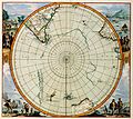
File:Detail of 1657 map Polus Antarcticus by Jan Janssonius, showing Nova Zeelandia.png

Size of this preview: 220 × 171 pixels. Other resolutions: 309 × 240 pixels | 482 × 375 pixels | 684 × 532 pixels.
Original file (684 × 532 pixels, file size: 508 KB, MIME type: image/png)
File history
Click on a date/time to view the file as it appeared at that time.
| Date/Time | Thumbnail | Dimensions | User | Comment | |
|---|---|---|---|---|---|
| current | 16:52, 25 January 2011 |  | 684 × 532 (508 KB) | wikimediacommons>Avenue | Higher resolution, stronger lines of latitude and longitude, different colours. |
File usage
The following page uses this file:

