.svg)
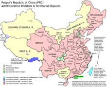
File:China administrative.png

Original file (857 × 699 pixels, file size: 95 KB, MIME type: image/png)
NOTE by original author
This map is no longer being updated. The newest version is in GIF format and is located at:

|
This map has been uploaded by Electionworld from en.wikipedia.org to enable the |
Administrative divisions of China. Made by Ran.
Features:
- Latest borders as of 2004. Qinghai-Gansu border readjustments are reflected; Sino-Russian agreement on the Amur-Ussuri delta is also (approximately) reflected.
- Disputed areas are given as neutral a treatment as possible.
The map was made based on a large-scale map of China made by woodhome and hunry of the XZQH forums.
Looking for translators!: If you want to translate the map into another language, here's a blank map that you can work with:
Alternatively, you can message me with the translated texts, and I will incorporate your translations for you and credit you for your work. (You don't have to translate the place names; I'll attempt to get them, as far as possible, from the Wikipedia in that language.) Same goes for any additions or corrections you'd like to make.
Translations have already been done for Spanish, German, Chinese (Simplified/Traditional), Japanese, French, Russian, Macedonian, Vietnamese, and Hebrew.
See also: en:Wikipedia:WikiProject Chinese provinces/Locator maps

|
Permission is granted to copy, distribute and/or modify this document under the terms of the GNU Free Documentation License, Version 1.2 or any later version published by the Free Software Foundation; with no Invariant Sections, no Front-Cover Texts, and no Back-Cover Texts. A copy of the license is included in the section entitled GNU Free Documentation License. |
| This file is licensed under the Creative Commons Attribution-Share Alike 3.0 Unported license. | ||
| ||
| This licensing tag was added to this file as part of the GFDL licensing update. |
File history
Click on a date/time to view the file as it appeared at that time.
| Date/Time | Thumbnail | Dimensions | User | Comment | |
|---|---|---|---|---|---|
| current | 01:13, 2 October 2011 | | 857 × 699 (95 KB) | wikimediacommons>Quigley | Southwest disputed area has its own name |
File usage
The following page uses this file: