.svg)
File:China.A2004040.0245.250m.jpg

Original file (5,600 × 7,200 pixels, file size: 5.4 MB, MIME type: image/jpeg)
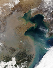
Haze over Eastern China 華北/華東的空氣污染
Credit: Jacques Descloitres, MODIS Rapid Response Team, NASA/GSFC
Across eastern China, the increased use of coal and wood for heating in the winter often leads to widespread haze, such as that seen in this Moderate Resolution Imaging Spectroradiometer (MODIS, [1]) image from the Terra satellite [2] on February 9, 2004. The topography contributes to the effect, as this region is very bowl-like and ringed by mountainous terrain to the west, which prevents the pollution from dispersing.
照片來源:美國國家航空暨太空總署 Jacques Descloitres
在整個華東地區,因冬季取暖而燃燒的煤炭和木材越來越多,經常引起廣泛分布的霧霾,譬如這張2004年2月9日從Terra衛星拍攝的照片所示。地形也是該現象的成因之一,因為這個地區地勢較低,西面又環繞了山地,從而阻止了污染的疏散。
參見:中國的空氣污染
| This file is in the public domain in the United States because it was solely created by NASA. NASA copyright policy states that "NASA material is not protected by copyright unless noted". (See Template:PD-USGov, NASA copyright policy page or JPL Image Use Policy.) | ||
 |
Warnings:
|
File history
Click on a date/time to view the file as it appeared at that time.
| Date/Time | Thumbnail | Dimensions | User | Comment | |
|---|---|---|---|---|---|
| current | 06:38, 20 March 2005 | | 5,600 × 7,200 (5.4 MB) | wikimediacommons>R.O.C | Haze over Eastern China 華北/華東的空氣污染 |
File usage
The following page uses this file: