.svg)
File:Chandigarh Tricity.svg

Size of this PNG preview of this SVG file: 220 × 163 pixels. Other resolutions: 320 × 236 pixels | 500 × 369 pixels | 1,444 × 1,067 pixels.
Original file (SVG file, nominally 1,444 × 1,067 pixels, file size: 1.27 MB)
Summary
| Description |
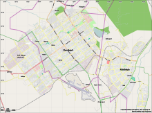
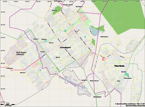
English: Location map for the Chandigarh Tricity, including Chandigarh UT, SAS Nagar, Panchkula and Zirakpur. |
| Date | |
| Source | OpenStreetMap.org (using Maperitive to create SVG file) |
| Author | Cropping by RaviC, OSM authors for map data |
| Camera location | | View this and other nearby images on: OpenStreetMap |
|---|
Licensing
| This work contains information from OpenStreetMap, which is made available under the Open Database License (ODbL).
The ODbL does not require any particular license for maps produced from ODbL data. Prior to 1 August 2020, map tiles produced by the OpenStreetMap Foundation were licensed under the CC-BY-SA-2.0 license. Maps produced by other people may be subject to other licences. |
File history
Click on a date/time to view the file as it appeared at that time.
| Date/Time | Thumbnail | Dimensions | User | Comment | |
|---|---|---|---|---|---|
| current | 22:31, 20 March 2021 | | 1,444 × 1,067 (1.27 MB) | wikimediacommons>RaviC | fixed Zirakpur |
File usage
The following 9 pages use this file: