.svg)
File:British Aden 1922.jpg

Size of this preview: 220 × 165 pixels. Other resolutions: 320 × 240 pixels | 500 × 375 pixels | 2,816 × 2,112 pixels.
Original file (2,816 × 2,112 pixels, file size: 803 KB, MIME type: image/jpeg)
Summary
| Description |
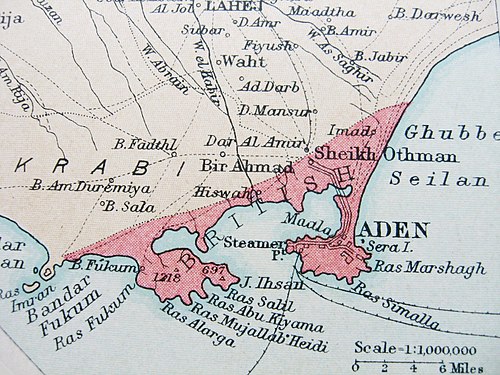
English: Segment of a 1922 map showing the 75 sq. mi. territory of British Aden, under direct British rule. The 'Aden Protectorate', the considerably larger hinterland, was under indirect British rule. The port city of Aden was captured by the East India Company in 1839 and until 1932, British Aden was a dependency of the Bombay Presidency ('Aden Settlement'). From 1932 to 1937, it was placed under the direct rule of the Viceroy of India ('Chief Commissioner's Province of Aden'). In 1937, the dependency became a Crown Colony ('Aden Colony') under the authority of the Colonial Office in London. In 1963, under the name 'State of Aden', it became a member of the British-protected Federation of South Arabia. Cropped from an insert of plate 78 (Egypt, the Nile and the Red Sea) of The Times Survey Atlas of the World published in 1922. |
| Date | |
| Source | Own work |
| Author | Lubiesque |
Licensing
I, the copyright holder of this work, hereby publish it under the following license:
This file is licensed under the Creative Commons Attribution-Share Alike 3.0 Unported license.
- You are free:
- to share – to copy, distribute and transmit the work
- to remix – to adapt the work
- Under the following conditions:
- attribution – You must give appropriate credit, provide a link to the license, and indicate if changes were made. You may do so in any reasonable manner, but not in any way that suggests the licensor endorses you or your use.
- share alike – If you remix, transform, or build upon the material, you must distribute your contributions under the same or compatible license as the original.
File history
Click on a date/time to view the file as it appeared at that time.
| Date/Time | Thumbnail | Dimensions | User | Comment | |
|---|---|---|---|---|---|
| current | 20:05, 19 July 2014 | | 2,816 × 2,112 (803 KB) | wikimediacommons>Xufanc | Lighter color |
File usage
The following page uses this file: