.svg)
File:6th 7th century Bhima Kichak Temple, Malhar Chhattisgarh India - 7.jpg

Original file (3,024 × 4,032 pixels, file size: 13.39 MB, MIME type: image/jpeg)
Summary
| Description |
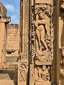
English: The Maurya, Shunga, Satvahana (pre-300 CE), then Somavamshi (c. 300 to 900 CE) and later Kalachuri dynasty (10th to 14th-century) developed a kingdom where Hindu (Shaivism), Jain and Buddhist communities thrived. This has become what is the modern state of Chhattisgarh. First Mallar, later Sripura (now Sirpur) was their capital. It was on the trade route linking the northwestern Indian kingdoms and Koshambi with those in the southeast, particularly Puri and major ports along the modern Andhra Pradesh. Sometime in and after the 14th-century, most of these were damaged and ruined in regional wars.
Each of these eras built exquisite temples and artistic items whose remains and ruins are seen from northern Chhattisgarh through western Telangana. The Bhima Kichak temple belongs to the Somavamshis era (c. 6th to 10th century). Inscriptions on stones, copper plate dedications and epigraphic evidence (language, script type) suggest that Malhar was variously called Sarabhapur, Malari, Mallar over its history. These are documented in inscriptions described and translated in Epigraphia Indica XXXIV. The Bhima Kichak temple survives in a ruined form with internal artwork and statues missing. The sanctum confirms the outlines (bhiti and lower portion) of a Shiva linga. The surviving walls have exquisitely carved ganas and numerous gavakshas with images of the common man or woman. The door jambs have near life size images of Ganga and Yamuna goddesses, a feature common to pre-7th century temples. Other reliefs show legends of Shiva and other Hindu epic legends. It is one of two surviving temple ruins in Malhar, Masturi, Bilaspur district. A museum in the village contains hundreds of ruined Hindu, Jaina and Buddhist artwork parts from these two and other temples. The temple is protected and managed by ASI Raipur circle. |
| Date | |
| Source | Own work |
| Author | Ms Sarah Welch |
| Camera location | | View this and other nearby images on: OpenStreetMap |
|---|
Licensing
- You are free:
- to share – to copy, distribute and transmit the work
- to remix – to adapt the work
- Under the following conditions:
- attribution – You must give appropriate credit, provide a link to the license, and indicate if changes were made. You may do so in any reasonable manner, but not in any way that suggests the licensor endorses you or your use.
- share alike – If you remix, transform, or build upon the material, you must distribute your contributions under the same or compatible license as the original.
File history
Click on a date/time to view the file as it appeared at that time.
| Date/Time | Thumbnail | Dimensions | User | Comment | |
|---|---|---|---|---|---|
| current | 01:39, 12 January 2021 | | 3,024 × 4,032 (13.39 MB) | wikimediacommons>Ms Sarah Welch | Uploaded own work with UploadWizard |
File usage
The following page uses this file: