
File:China India CIA map border disputes.jpg
Size of this preview: 220 × 165 pixels. Other resolutions: 320 × 240 pixels | 652 × 490 pixels.
Original file (652 × 490 pixels, file size: 93 KB, MIME type: image/jpeg)

|
This map image could be re-created using vector graphics as a SVG file. This has several advantages; see Commons:Media for cleanup for more information. If a SVG form of this image is available, please upload it and afterwards replace this template with
{{vector version available|new image name}}.It is recommended to name the SVG file “China India CIA map border disputes.svg”—then the template Vector version available (or Vva) does not need the new image name parameter. |


Summary
| DescriptionChina India CIA map border disputes.jpg |
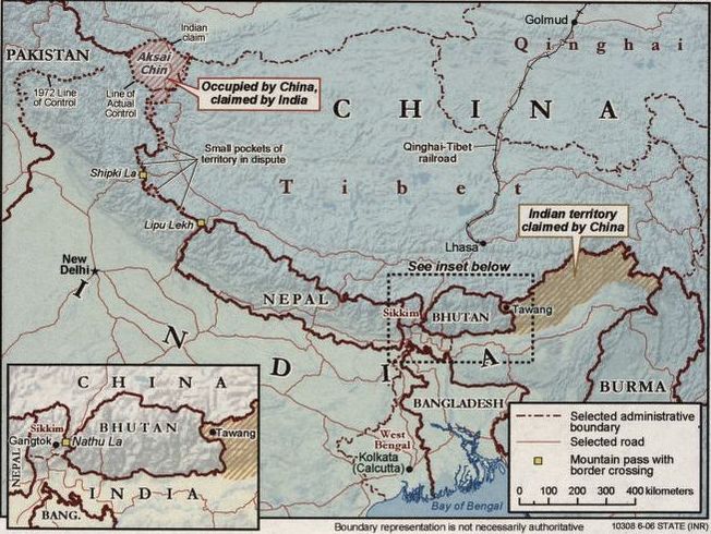
English: Shows southern part of China and northern part of India. Border disputes marked. "Boundary representation is not necessarily authoritative" |
| Date | |
| Source | Library of Congress |
| Author | United States. Central Intelligence Agency. |
Licensing
| Public domainPublic domainfalsefalse |

|
This work is in the public domain in the United States because it is a work prepared by an officer or employee of the United States Federal Government as part of that person’s official duties under the terms of Title 17, Chapter 1, Section 105 of the US Code.
Note: This only applies to original works of the Federal Government and not to the work of any individual U.S. state, territory, commonwealth, county, municipality, or any other subdivision. This template also does not apply to postage stamp designs published by the United States Postal Service since 1978. (See § 313.6(C)(1) of Compendium of U.S. Copyright Office Practices). It also does not apply to certain US coins; see The US Mint Terms of Use.
|
 |
| This file has been identified as being free of known restrictions under copyright law, including all related and neighboring rights. | ||
https://creativecommons.org/publicdomain/mark/1.0/PDMCreative Commons Public Domain Mark 1.0falsefalse
Captions
China and India map with border disputes marked.
File history
Click on a date/time to view the file as it appeared at that time.
| Date/Time | Thumbnail | Dimensions | User | Comment | |
|---|---|---|---|---|---|
| current | 10:47, 16 June 2020 |  | 652 × 490 (93 KB) | smartcommons>FacetsOfNonStickPans | Cropped 20 % horizontally, 55 % vertically using CropTool with precise mode. |
File usage
The following 5 pages use this file:
- Agreement on the Political Parameters and Guiding Principles for the Settlement of the India-China Boundary Question, 2005
- India-China Joint Working Group on the boundary question
- Indian Chinese cuisine
- Line of Actual Control
- Working Mechanism for Consultation and Coordination on India-China Border Affairs
