.svg)
Dayara Bugyal
| Dayara Bugyal | |
|---|---|
 Dayara Bugyal | |
| Highest point | |
| Elevation | 3,639 m (11,939 ft) |
| Coordinates | 30°50′18″N 78°33′18″E / 30.8383656°N 78.5550349°E |
| Geography | |
| Location | Uttarkashi district, Uttarakhand, India |
| Parent range | Garhwal Himalaya |
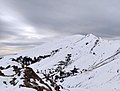
Dayara Bugyal is a Bugyal (Himalayan Alpine Meadow) in the Uttarkashi district of Uttarakhand. Dayara Bugyal is a popular Trekking and Camping Destination. The Bugyal has an average elevation of 3639m and is around 40 km from Uttarkashi. It can be accessed via various basecamp villages like Raithal, Barsu, and Natin. Dayara Bugyal is nestled between the Deodar and Rhododendron trees and is rich in flora and fauna.[1] Ahead of Dayara Bugyal there are more bugyals like Siyari Bugyal and Gidara Bugyal.[2]
Dayara Bugyal is also a destination for trekking as well as camping. In spring, there is contrast of greenery of the grasslands and red and pink rhododendrons.[3] In winters, the Bugyal turns into snow land with capability of skiing and snow activities. The trek is open throughout the year except the monsoon. Views of the Garhwal Himalayas, including Bandarpunch, Black Peak, Gangotri ranges, Draupadi Ka Danda, Srikanth can be seen from Dayara Bugyal.[4]
Gallery
![Dayara Bugyal]](https://upload.wikimedia.org/wikipedia/commons/thumb/3/39/Dayara_Bugyal.jpg/120px-Dayara_Bugyal.jpg)
Dayara Bugyal]
Summit

Dayara Bugyal Grasslands covered with snow


References
- ↑ "Dayara Bugyal". Uttarkashi.nic.in.
- ↑ Dayara Bugyal: Meadow, Sustainable living and Adventure activities
- ↑ "Dayara Bugyal". indiahikes.com.
- ↑ "Dayara Bugyal". euttaranchal.com.
This article related to a location in the Indian state of Uttarakhand is a stub. You can help Wikipedia by expanding it. |