



→History: Title case Tipu Sultan's name |
m brief reworked page to improve readability additionally and cleaned formatting |
||
| Line 1: | Line 1: | ||
{{Short description|Hilltop fortification in Karnataka, India}} | |||
{{other places}} | {{other places}} | ||
{{Use dmy dates|date=July 2019}} | {{Use dmy dates|date=July 2019}} | ||
{{Infobox | {{Infobox military installation | ||
|name = Jamalabad Fort | |name = Jamalabad Fort | ||
|native_name = | |native_name = | ||
| Line 36: | Line 37: | ||
[[File:Gadaikallu entrance.JPG|thumb|Gadaikallu entrance, <br>Reading: Welcome to Jamlabad, height: 1700 feet]] | [[File:Gadaikallu entrance.JPG|thumb|Gadaikallu entrance, <br>Reading: Welcome to Jamlabad, height: 1700 feet]] | ||
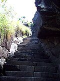
[[File:JamalabadFortPassage.jpg|thumb|Narrow steps leading to the fort]] | [[File:JamalabadFortPassage.jpg|thumb|Narrow steps leading to the fort]] | ||
The fort was built by [[Tipu Sultan]] in 1794<ref name="Ranade">{{Cite book|author=Ranade, Prabha Shastri|year=2009|chapter=Chapter 5: Tourism Development|title=Infrastructure Development and Its Environmental Impact: Study of Konkan Railway|location=New Delhi|publisher=Concept Publishing Company|page=[https://books.google.com/books?id=cGSKjaym3TcC&pg=PA162 162]|url=https://books.google.com/books?id=cGSKjaym3TcC|isbn=978-81-8069-450-9}}</ref> and named after his mother, Jamalabee. He decided to build a fort there, as he was impressed by the massive [[granite|granitic]] rock which was suitable for the construction of a strong fort. According to locals, it was built to serve as a watch tower to see things around when enemy attacked.there is a lake situated at the top which is used to store water, | The fort was built by [[Tipu Sultan]] in 1794<ref name="Ranade">{{Cite book|author=Ranade, Prabha Shastri|year=2009|chapter=Chapter 5: Tourism Development|title=Infrastructure Development and Its Environmental Impact: Study of Konkan Railway|location=New Delhi|publisher=Concept Publishing Company|page=[https://books.google.com/books?id=cGSKjaym3TcC&pg=PA162 162]|url=https://books.google.com/books?id=cGSKjaym3TcC|isbn=978-81-8069-450-9}}</ref> and named after his mother, Jamalabee. He decided to build a fort there, as he was impressed by the massive [[granite|granitic]] rock which was suitable for the construction of a strong fort. According to locals, it was built to serve as a watch tower to see things around when enemy attacked.there is a lake situated at the top which is used to store water, it's truly mesmerising to watch the sight.<ref>{{Cite book | ||
|last=Bhat | |last=Bhat | ||
|first=N. Shyam | |first=N. Shyam | ||
| Line 52: | Line 53: | ||
==Trekking== | ==Trekking== | ||
{{Unreferenced section|date=December 2015}} | {{Unreferenced section|date=December 2015}} | ||
Jamalabad Fort is a [[trekking]] destination, with the climb up to the fort being classified as 'medium difficulty level' and the top of the structure offering good views of the surrounding landscape and the [[Kudremukh]] range. | Jamalabad Fort is a [[trekking]] destination, with the climb up to the fort being classified as 'medium difficulty level'<ref>{{Cite web |date=5 October 2021 |title=Partial hike to Jamalabad fort - eNidhi India Travel Blog |url=https://www.enidhi.net/2021/10/partial-hike-to-jamalabad-fort.html |access-date=2024-11-05 |website=www.enidhi.net}}</ref> and the top of the structure offering good views of the surrounding landscape and the [[Kudremukh]] range. | ||
At the base of the hill is a forest check post where visitors have to pay a nominal entry fee. Visitors should carry food and plenty of water since there is no potable fresh water available on top. The nearest town with any communication and medical facilities is [[Beltangady]]. | At the base of the hill is a forest check post where visitors have to pay a nominal entry fee. Visitors should carry food and plenty of water since there is no potable fresh water available on top. The nearest town with any communication and medical facilities is [[Beltangady]]. | ||
| Line 69: | Line 70: | ||
== Citations == | == Citations == | ||
{{ | {{commons category|Jamalabad}} | ||
{{reflist}} | {{reflist}} | ||
{{ | {{Clear}} | ||
{{Coord|13|1|37.38|N|75|17|41.02|E|region:IN_type:landmark_dim:20|display=title}} | {{Coord|13|1|37.38|N|75|17|41.02|E|region:IN_type:landmark_dim:20|display=title}} | ||
| Line 77: | Line 78: | ||
{{Forts in Karnataka}} | {{Forts in Karnataka}} | ||
[[Category: Forts in Karnataka]] | [[Category:Forts in Karnataka]] | ||
[[Category: Buildings and structures in Dakshina Kannada district]] | [[Category:Buildings and structures in Dakshina Kannada district]] | ||
{{Karnataka-stub}} | {{Karnataka-stub}} | ||
Latest revision as of 16:48, 25 March 2026
| Jamalabad Fort | |
|---|---|
| Part of Karnataka | |
| Belthangady, Karnataka, India | |
.jpg) Jamalabad Fort | |
| Type | Fort |
| Site information | |
| Controlled by | Government of Karnataka |
| Condition | Ruins |
| Site history | |
| Built | 1794 |
| Built by | Kingdom of Mysore |
| Materials | Granite Stones and lime mortar |
| Airfield information | |
| Elevation | 320 AMSL |
Jamalabad Fort is an old hilltop fortification in Killoor road, Belthangady, Dakshina Kannada District, Karnataka, India. It is located in the Kudremukh range of hills,[1] 8 km north of Beltangady town and 65 km from the city of Mangalore. It is also referred locally as "Jamalabad Fort" or "Gadaikallu".
History[edit | edit source]

Reading: Welcome to Jamlabad, height: 1700 feet

The fort was built by Tipu Sultan in 1794[1] and named after his mother, Jamalabee. He decided to build a fort there, as he was impressed by the massive granitic rock which was suitable for the construction of a strong fort. According to locals, it was built to serve as a watch tower to see things around when enemy attacked.there is a lake situated at the top which is used to store water, it's truly mesmerising to watch the sight.[2]
The fort is accessible via a narrow path, with around 1876 steps to the fort that are cut out of the granite hill and lead all the way to the top.
Inside the fort, there is a tank to store rainwater. Remains of a single cannon lie at the top. Nothing much of the fortifications remain but hints of the fort wall with parapets are visible. The fort was captured by the British in 1799 during the 4th Mysore war. Legend has it that those out of favour with Tipu were hurled down the edge to their death.[3]
Trekking[edit | edit source]
 |
Jamalabad Fort is a trekking destination, with the climb up to the fort being classified as 'medium difficulty level'[4] and the top of the structure offering good views of the surrounding landscape and the Kudremukh range.
At the base of the hill is a forest check post where visitors have to pay a nominal entry fee. Visitors should carry food and plenty of water since there is no potable fresh water available on top. The nearest town with any communication and medical facilities is Beltangady.
Entry to the fort is open between 6 am and 4 pm and overnight stay at the fort is prohibited. This hillock fort has one room at the top.
There is also an unmanned microwave repeater station on top of the hill. Being a hill station it is really cold there and suggested to wear warm and comfortable clothes due to lot of walking.
The peak is 520m above MSL, while the surrounding area is less than 200m, meaning the trek is considerably steep.

See also[edit | edit source]
Citations[edit | edit source]
- ↑ 1.0 1.1 Ranade, Prabha Shastri (2009). "Chapter 5: Tourism Development". Infrastructure Development and Its Environmental Impact: Study of Konkan Railway. New Delhi: Concept Publishing Company. p. 162. ISBN 978-81-8069-450-9.
- ↑ Bhat, N. Shyam (1998). South Kanara, 1799–1860: a study in colonial administration and regional response. Mittal Publications. p. 81. ISBN 9788170995869. Retrieved 9 May 2020.
- ↑ "A Fortress that Tipu once held". Deccan herald. Retrieved 28 June 2010.
- ↑ "Partial hike to Jamalabad fort - eNidhi India Travel Blog". www.enidhi.net. 5 October 2021. Retrieved 5 November 2024.
13°1′37.38″N 75°17′41.02″E / 13.0270500°N 75.2947278°E
 | This Karnataka-related article is a stub. You can help Bharatpedia by expanding it. |