



m robot: Update article (please report if you notice any mistake or error in this edit) |
refined article as per guidelines and fixed typos based on references |
||
| Line 2: | Line 2: | ||
{{Use dmy dates|date=September 2019}} | {{Use dmy dates|date=September 2019}} | ||
{{Use Indian English|date=September 2019}} | {{Use Indian English|date=September 2019}} | ||
The '''Paravur Estuaries''' are a group of estuaries in [[Paravur, Kollam|Paravur]], [[India]], near the South-Western coast of [[Kollam district]], [[Kerala]].<ref>{{cite web|url=http://www.indianofficer.com/topic/2152-estuaries-of-india/ |title=Estuaries Of India |access-date=16 March 2015}}</ref> Paravur is one among the 4 municipal towns in Kollam district, Kerala state. The place is known for its natural beauties, backwater locations, white-sand beaches and concentration of temples.<ref>{{cite web|url=http://www.paravurmunicipality.in/ml/history |title=Paravur Municipality |access-date=16 March 2015}}</ref> | The '''Paravur Estuaries''' are a group of estuaries in [[Paravur, Kollam|Paravur]], [[India]], near the South-Western coast of [[Kollam district]], [[Kerala]].<ref>{{cite web|url=http://www.indianofficer.com/topic/2152-estuaries-of-india/ |title=Estuaries Of India |access-date=16 March 2015}}</ref> Paravur is one among the 4 municipal towns in Kollam district, Kerala state. The place is known for its natural beauties, backwater locations, white-sand beaches and concentration of temples.<ref>{{cite web |url=http://www.paravurmunicipality.in/ml/history |title=Paravur Municipality |access-date=16 March 2015 |archive-date=10 October 2017 |archive-url=https://web.archive.org/web/20171010082406/http://www.paravurmunicipality.in/ml/history |url-status=dead }}</ref> | ||
[[File:Boating at Paravur Lake, Thekkumbhagam.jpg|right|thumb|Boating at [[Paravur Lake]]]] | [[File:Boating at Paravur Lake, Thekkumbhagam.jpg|right|thumb|Boating at [[Paravur Lake]]]] | ||
[[File:Thekkumbhagam-Kappil bridge, Paravur.jpg|right|thumb|[[Thekkumbhagam]]-[[Kappil, Thiruvananthapuram|Kappil]] bridge as seen from Paravur Estuary. This bridge is the official border of [[Paravur, Kollam|Paravur]] town towards south]] | [[File:Thekkumbhagam-Kappil bridge, Paravur.jpg|right|thumb|[[Thekkumbhagam]]-[[Kappil, Thiruvananthapuram|Kappil]] bridge as seen from Paravur Estuary. This bridge is the official border of [[Paravur, Kollam|Paravur]] town towards south]] | ||
| Line 8: | Line 8: | ||
==Geography== | ==Geography== | ||
[[File:Paravur backwaters & beaches.jpg|right|thumb|[[Pozhikkara]] peninsula in the north of [[Paravur, Kollam|Paravur]] town]] | [[File:Paravur backwaters & beaches.jpg|right|thumb|[[Pozhikkara]] peninsula in the north of [[Paravur, Kollam|Paravur]] town]] | ||
[[Paravur, Kollam|Paravur]] is a land of beaches, backwaters & estuaries. The [[Paravur, Kollam|Paravur]] landmass's three sides are surrounded by water bodies - [[Paravur Lake]], Nadayara Lake and the [[Arabian Sea]]. [[Paravur Lake]] is the main body of water in the town area, having a catchment area of 6.62 km<sup>2</sup>. The peninsula of [[Paravur, Kollam|Paravur]] is one of the most visited areas in [[Kollam district]]. Both north and south tips of [[Paravur, Kollam|Paravur]] town have peninsulas and estuaries. [[Pozhikara]] is to the north and [[Thekkumbhagam]] is to the south of [[Paravur, Kollam|Paravur]].<ref>{{cite web|url=http://www.indianofficer.com/topic/2152-estuaries-of-india/ |title=Estuaries of India |access-date=16 March 2015}}</ref><ref>{{cite web|url=http://www.iaeng.org/publication/WCE2009/WCE2009_pp694-699.pdf |title=Impact of Sea-Sand Filling in the Paravur-Kappil Backwaters, Southern Kerala with Special Reference to Phytoplankton Productivity |access-date=16 March 2015}}</ref> One more estuary mouth is in [[Pozhikara]], which is very close to [[Pozhikara]] Devi Temple, which has breached in 2014 under the supervision of Water Resources Department (WRD), after a long gap of 14 years.<ref>{{cite web|url=http://www.thehindu.com/news/national/kerala/paravur-estuary-breached/article5960820.ece |title=Paravur estuary breached :The Hindu |access-date=16 March 2015}}</ref> | [[Paravur, Kollam|Paravur]] is a land of beaches, backwaters & estuaries. The [[Paravur, Kollam|Paravur]] landmass's three sides are surrounded by water bodies - [[Paravur Lake]], Nadayara Lake and the [[Arabian Sea]]. [[Paravur Lake]] is the main body of water in the town area, having a catchment area of 6.62 km<sup>2</sup>. The peninsula of [[Paravur, Kollam|Paravur]] is one of the most visited areas in [[Kollam district]]. Both north and south tips of [[Paravur, Kollam|Paravur]] town have peninsulas and estuaries. [[Pozhikara]] is to the north and [[Thekkumbhagam]] is to the south of [[Paravur, Kollam|Paravur]].<ref>{{cite web|url=http://www.indianofficer.com/topic/2152-estuaries-of-india/ |title=Estuaries of India |access-date=16 March 2015}}</ref><ref>{{cite web|url=http://www.iaeng.org/publication/WCE2009/WCE2009_pp694-699.pdf |title=Impact of Sea-Sand Filling in the Paravur-Kappil Backwaters, Southern Kerala with Special Reference to Phytoplankton Productivity |access-date=16 March 2015}}</ref> One more estuary mouth is in [[Pozhikara]], which is very close to [[Pozhikara]] Devi Temple, which has breached in 2014 under the supervision of Water Resources Department (WRD), after a long gap of 14 years.<ref>{{cite web|url=http://www.thehindu.com/news/national/kerala/paravur-estuary-breached/article5960820.ece |title=Paravur estuary breached :The Hindu |website=[[The Hindu]] |access-date=16 March 2015}}</ref> | ||
The estuaries can be reached by travelling through [[Kollam-Paravur Coastal Road]] and [[Paravur, Kollam|Paravur]]-[[Kappil, Thiruvananthapuram|Kappil]]-[[Varkala]] road.<ref>{{cite book|url=https://books.google.com/books?id=Tu0imj39FwkC&q=paravoor+pozhikkara+population&pg=PA186 |title=Coastal Zone Management: By Ramakrishnan Korakandy |isbn=9788178353036 |access-date=16 March 2015|last1=Korakandy |first1=Ramakrishnan |year=2005 }}</ref><ref>{{cite web|url=http://in.geoview.info/paravurpozhikkarathanni_road,101048972w |title=Paravur-Pozhikkara-Thanni Road |access-date=16 March 2015}}</ref><ref>{{cite web|url=http://www.thehindu.com/news/national/kerala/elephant-swoons-dies-by-roadside-in-pozhikkara/article5708823.ece |title=Elephant swoons, dies by roadside in Pozhikkara : The Hindu |access-date=16 March 2015}}</ref> The 600 hectare [[Polachira|Polachira Wetland]] is also close to [[Paravur, Kollam|Paravur]].<ref>{{cite web|url=http://www.thehindu.com/news/national/kerala/sediment-analysis-decodes-climate-history/article5996533.ece |title=Sediment analysis decodes climate history : The Hindu |access-date=16 March 2015}}</ref> | The estuaries can be reached by travelling through [[Kollam-Paravur Coastal Road]] and [[Paravur, Kollam|Paravur]]-[[Kappil, Thiruvananthapuram|Kappil]]-[[Varkala]] road.<ref>{{cite book|url=https://books.google.com/books?id=Tu0imj39FwkC&q=paravoor+pozhikkara+population&pg=PA186 |title=Coastal Zone Management: By Ramakrishnan Korakandy |isbn=9788178353036 |access-date=16 March 2015|last1=Korakandy |first1=Ramakrishnan |year=2005 }}</ref><ref>{{cite web|url=http://in.geoview.info/paravurpozhikkarathanni_road,101048972w |title=Paravur-Pozhikkara-Thanni Road |access-date=16 March 2015}}</ref><ref>{{cite web|url=http://www.thehindu.com/news/national/kerala/elephant-swoons-dies-by-roadside-in-pozhikkara/article5708823.ece |title=Elephant swoons, dies by roadside in Pozhikkara : The Hindu |website=[[The Hindu]] |access-date=16 March 2015}}</ref> The 600 hectare [[Polachira|Polachira Wetland]] is also close to [[Paravur, Kollam|Paravur]].<ref>{{cite web|url=http://www.thehindu.com/news/national/kerala/sediment-analysis-decodes-climate-history/article5996533.ece |title=Sediment analysis decodes climate history : The Hindu |website=[[The Hindu]] |access-date=16 March 2015}}</ref> | ||
==Pozhi== | ==Pozhi== | ||
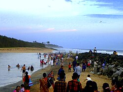
[[File:Thekkumbhagam Estuary, Paravur.jpg|right|thumb|Paravur Estuary mouth at [[Thekkumbhagam]]]] | [[File:Thekkumbhagam Estuary, Paravur.jpg|right|thumb|Paravur Estuary mouth at [[Thekkumbhagam]]]] | ||
''Pozhi'' is a natural phenomena of formation of a sand bar along the coast separating sea and backwaters in the peninsula areas during summer season but which erode during the monsoon season, allowing the sea to be merged with the backwaters. Paravur backwaters' on both the north (Thanni beach) and south ends ([[Thekkumbhagam]] beach) have ''Pozhi''. Both meet the [[Arabian Sea]] in the district's beach faces. There is an artificial tidal-regulator in the spillway bridge at [[Pozhikara]] estuarine area, constructed in 1957 to control the salt water intrusion into [[Paravur Lake]].<ref>{{cite web|url=http://www.neptjournal.com/journal-details.php?id=1&q_id=1 |title=Nept Journal |access-date=16 March 2015}}</ref> This phenomenon provides abundant water for people living in the Grama panchayats of [[Ithikkara]], [[Velinalloor]], [[Pooyappally]], [[Adichanalloor]], parts of [[Poothakkulam]], [[Polachira]], [[Mayyanad]], [[Chirakkara]], [[Chathannoor]], Elakamon, [[Edava]] and the [[Paravur, Kollam|Paravur]] municipal area.<ref>{{cite web|url=http://www.thehindu.com/news/national/kerala/paravur-estuary-gets-blocked-wells-swell/article5950749.ece |title=Paravur estuary gets blocked, wells swell : The Hindu |access-date=16 March 2015}}</ref> | ''Pozhi'' is a natural phenomena of formation of a sand bar along the coast separating sea and backwaters in the peninsula areas during summer season but which erode during the monsoon season, allowing the sea to be merged with the backwaters. Paravur backwaters' on both the north (Thanni beach) and south ends ([[Thekkumbhagam]] beach) have ''Pozhi''. Both meet the [[Arabian Sea]] in the district's beach faces. There is an artificial tidal-regulator in the spillway bridge at [[Pozhikara]] estuarine area, constructed in 1957 to control the salt water intrusion into [[Paravur Lake]].<ref>{{cite web |url=http://www.neptjournal.com/journal-details.php?id=1&q_id=1 |title=Nept Journal |access-date=16 March 2015 |archive-date=2 April 2015 |archive-url=https://web.archive.org/web/20150402164743/http://www.neptjournal.com/journal-details.php?id=1&q_id=1 |url-status=dead }}</ref> This phenomenon provides abundant water for people living in the Grama panchayats of [[Ithikkara]], [[Velinalloor]], [[Pooyappally]], [[Adichanalloor]], parts of [[Poothakkulam]], [[Polachira]], [[Mayyanad]], [[Chirakkara]], [[Chathannoor]], Elakamon, [[Edava]] and the [[Paravur, Kollam|Paravur]] municipal area.<ref>{{cite web|url=http://www.thehindu.com/news/national/kerala/paravur-estuary-gets-blocked-wells-swell/article5950749.ece |title=Paravur estuary gets blocked, wells swell : The Hindu |website=[[The Hindu]] |access-date=16 March 2015}}</ref> | ||
==Paravur Lake== | ==Paravur Lake== | ||
{{main|Paravur Lake}} | {{main|Paravur Lake}} | ||
[[File:Paravur Lake, Kollam - An evening scene.jpg|right|thumb|An evening view of [[Paravur Lake]]]] | [[File:Paravur Lake, Kollam - An evening scene.jpg|right|thumb|An evening view of [[Paravur Lake]]]] | ||
[[Paravur Lake]] is a lake in [[Paravur, Kollam|Paravur]], [[Kerala]], [[India]].<ref>[http://civildigital.com/study-various-lakes-kerala-environmental-issues/ A Study on Various Lakes In Kerala and Environmental Issues]</ref> Although it is small, with an area of only 6.62 km<sup>2</sup>,<ref> | [[Paravur Lake]] is a lake in [[Paravur, Kollam|Paravur]], [[Kerala]], [[India]].<ref>[http://civildigital.com/study-various-lakes-kerala-environmental-issues/ A Study on Various Lakes In Kerala and Environmental Issues]</ref> Although it is small, with an area of only 6.62 km<sup>2</sup>,<ref>{{Cite web |url=http://www.kerala.gov.in/statistical/panchayat_statistics2001/klm_glnc.htm |title=Kollam at a Glance |access-date=16 March 2015 |archive-date=2 October 2008 |archive-url=https://web.archive.org/web/20081002103305/http://www.kerala.gov.in/statistical/panchayat_statistics2001/klm_glnc.htm |url-status=dead }}</ref> it is the end point of the [[Ithikkara River]] and part of the system of lakes and [[canal]]s that make up the [[Kerala Backwaters]]. It has been connected to [[Edava]] and [[Ashtamudi Kayal]] as part of the [[Trivandrum - Shoranur canal]] system since the late 19th century. | ||
==References== | ==References== | ||
| Line 30: | Line 30: | ||
[[Category:Estuaries of India]] | [[Category:Estuaries of India]] | ||
[[Category:Tourist attractions in Kollam district]] | [[Category:Tourist attractions in Kollam district]] | ||
[[Category:Wetlands in Kollam district]] | |||
Latest revision as of 20:09, 28 February 2026
The Paravur Estuaries are a group of estuaries in Paravur, India, near the South-Western coast of Kollam district, Kerala.[1] Paravur is one among the 4 municipal towns in Kollam district, Kerala state. The place is known for its natural beauties, backwater locations, white-sand beaches and concentration of temples.[2]


Geography[edit | edit source]

Paravur is a land of beaches, backwaters & estuaries. The Paravur landmass's three sides are surrounded by water bodies - Paravur Lake, Nadayara Lake and the Arabian Sea. Paravur Lake is the main body of water in the town area, having a catchment area of 6.62 km2. The peninsula of Paravur is one of the most visited areas in Kollam district. Both north and south tips of Paravur town have peninsulas and estuaries. Pozhikara is to the north and Thekkumbhagam is to the south of Paravur.[3][4] One more estuary mouth is in Pozhikara, which is very close to Pozhikara Devi Temple, which has breached in 2014 under the supervision of Water Resources Department (WRD), after a long gap of 14 years.[5]
The estuaries can be reached by travelling through Kollam-Paravur Coastal Road and Paravur-Kappil-Varkala road.[6][7][8] The 600 hectare Polachira Wetland is also close to Paravur.[9]
Pozhi[edit | edit source]

Pozhi is a natural phenomena of formation of a sand bar along the coast separating sea and backwaters in the peninsula areas during summer season but which erode during the monsoon season, allowing the sea to be merged with the backwaters. Paravur backwaters' on both the north (Thanni beach) and south ends (Thekkumbhagam beach) have Pozhi. Both meet the Arabian Sea in the district's beach faces. There is an artificial tidal-regulator in the spillway bridge at Pozhikara estuarine area, constructed in 1957 to control the salt water intrusion into Paravur Lake.[10] This phenomenon provides abundant water for people living in the Grama panchayats of Ithikkara, Velinalloor, Pooyappally, Adichanalloor, parts of Poothakkulam, Polachira, Mayyanad, Chirakkara, Chathannoor, Elakamon, Edava and the Paravur municipal area.[11]
Paravur Lake[edit | edit source]

Paravur Lake is a lake in Paravur, Kerala, India.[12] Although it is small, with an area of only 6.62 km2,[13] it is the end point of the Ithikkara River and part of the system of lakes and canals that make up the Kerala Backwaters. It has been connected to Edava and Ashtamudi Kayal as part of the Trivandrum - Shoranur canal system since the late 19th century.
References[edit | edit source]
- ↑ "Estuaries Of India". Retrieved 16 March 2015.
- ↑ "Paravur Municipality". Archived from the original on 10 October 2017. Retrieved 16 March 2015.
- ↑ "Estuaries of India". Retrieved 16 March 2015.
- ↑ "Impact of Sea-Sand Filling in the Paravur-Kappil Backwaters, Southern Kerala with Special Reference to Phytoplankton Productivity" (PDF). Retrieved 16 March 2015.
- ↑ "Paravur estuary breached :The Hindu". The Hindu. Retrieved 16 March 2015.
- ↑ Korakandy, Ramakrishnan (2005). Coastal Zone Management: By Ramakrishnan Korakandy. ISBN 9788178353036. Retrieved 16 March 2015.
- ↑ "Paravur-Pozhikkara-Thanni Road". Retrieved 16 March 2015.
- ↑ "Elephant swoons, dies by roadside in Pozhikkara : The Hindu". The Hindu. Retrieved 16 March 2015.
- ↑ "Sediment analysis decodes climate history : The Hindu". The Hindu. Retrieved 16 March 2015.
- ↑ "Nept Journal". Archived from the original on 2 April 2015. Retrieved 16 March 2015.
- ↑ "Paravur estuary gets blocked, wells swell : The Hindu". The Hindu. Retrieved 16 March 2015.
- ↑ A Study on Various Lakes In Kerala and Environmental Issues
- ↑ "Kollam at a Glance". Archived from the original on 2 October 2008. Retrieved 16 March 2015.

