

>Pinakpani |
robot: Update article (please report if you notice any mistake or error in this edit) |
||
| Line 2: | Line 2: | ||
{{Infobox ancient site | {{Infobox ancient site | ||
|name = Ballal Dhipi | |name = Ballal Dhipi | ||
|native_name = '''[[List of Monuments of National Importance in West Bengal|Monument | |native_name = '''An [[Archaeological Survey of India|ASI]] [[List of Monuments of National Importance in West Bengal|Listed Monument]]''' | ||
|alternate_name = | |alternate_name = | ||
|image = File:Ballal Dhipi, Bamunpukur, West Bengal 03.jpg | |image = File:Ballal Dhipi, Bamunpukur, West Bengal 03.jpg | ||
| Line 47: | Line 47: | ||
}} | }} | ||
'''Ballal Dhipi''' is an | '''Ballal Dhipi''' is a historic archeological site on the eastern flood plain of the [[Hooghly River|Hooghly]] in Nadia, West Bengal, a few kilometres east of Nabadwip. The remains date back to the 12th century AD and earlier. A 30-ft structure of solid terracotta bricks is spread over an area of 1,300 sq ft. with a floor made of lime and sand. It is named after [[Ballala Sena]] (1160-1179) of the [[Sena dynasty]]. | ||
Archaeologists have found traces of a temple complex. Historians differ on the origin of the structure. It may be the ruin of a Buddhist ''stupa'' or ''vihar'', possibly built between the 11th and 13th centuries. It has similarities with [[Vikramashila|Vikramshila]] Vihar, in Bihar and [[Somapura Mahavihara|Shompur]] Vihar, in Rajshahi, Bangladesh. It may also be a part of the capital of the Sena dynasty. | |||
==Geography== | ==Geography== | ||
| Line 95: | Line 97: | ||
===Location=== | ===Location=== | ||
Ballal Dhipi is located at {{coord|23.4503|N|88.4014|E|display=inline}}. | Ballal Dhipi is located at Bamunpukur, near Mayapur and Nabadwip, {{coord|23.4503|N|88.4014|E|display=inline}}. | ||
<small>Note: The map alongside presents some of the notable locations in the subdivision. All places marked in the map are linked in the larger full screen map.</small> | <small>Note: The map alongside presents some of the notable locations in the subdivision. All places marked in the map are linked in the larger full screen map.</small> | ||
==Excavations== | ===Excavations=== | ||
The Kolkata Circle of the [[Archaeological Survey of India]] excavated the mound, during 1982-1988, and “exposed huge brick structures and various antiquities datable to c. 10th to 12th cent. AD. The brick structure include shrines on sides and a massive construction within an enclosure.” The antiquities indicate the possibility of Buddhist affiliation. The structural complex covers nearly 13,000 m<sup>2</sup>. Experts opine the “stupa(vihara) of eighth/ ninth century was perhaps a seat of learning and pilgrimage up to the end of the 11th century.” It is about 25 km from [[Krishnanagar, Nadia|Krishnanagar]].<ref>{{cite web | url = http://www.asikolkata.in/nadia.aspx | title = Mound known as Bamanpukur Mound of Fort | publisher = ASI, Kolkata Circle | accessdate = 18 October 2020}}</ref><ref>{{cite web | url = http://www.nadia.nic.in/Tourism-Details/tourism-details.html | title = Pilgrimages & Tourist Spots| work = Ballal Dhipi| publisher = Egiye Bangla, official website of Nadia district | accessdate = 18 October 2020}}</ref> | The Kolkata Circle of the [[Archaeological Survey of India]] excavated the mound, during 1982-1988, and “exposed huge brick structures and various antiquities datable to c. 10th to 12th cent. AD. The brick structure include shrines on sides and a massive construction within an enclosure.” The antiquities indicate the possibility of Buddhist affiliation. The structural complex covers nearly 13,000 m<sup>2</sup>. Experts opine the “stupa(vihara) of eighth/ ninth century was perhaps a seat of learning and pilgrimage up to the end of the 11th century.” It is about 25 km from [[Krishnanagar, Nadia|Krishnanagar]].<ref>{{cite web | url = http://www.asikolkata.in/nadia.aspx | title = Mound known as Bamanpukur Mound of Fort | publisher = ASI, Kolkata Circle | accessdate = 18 October 2020}}</ref><ref>{{cite web | url = http://www.nadia.nic.in/Tourism-Details/tourism-details.html | title = Pilgrimages & Tourist Spots| work = Ballal Dhipi| publisher = Egiye Bangla, official website of Nadia district | accessdate = 18 October 2020}}</ref> | ||
The ASI has divided the site into two parts – the mound and the remains of a fort. Both the sites are identified as [[List of Monuments of National Importance in West Bengal| | The ASI has divided the site into two parts – the mound and the remains of a fort. Both the sites are identified as an [[List of Monuments of National Importance in West Bengal|ASI listed monument]].<ref>{{Cite web|url=http://asi.nic.in/alphabetical-list-of-monuments-west-bengal/|title=List of Ancient Monuments and Archaeological Sites and Remains of West Bengal - Archaeological Survey of India|publisher= ASI|work= Item nos. 130&131|access-date=18 October 2020}}</ref> | ||
==Ballal Dhipi picture gallery== | ==Ballal Dhipi picture gallery== | ||
Revision as of 18:26, 6 December 2021
 Ballal Dhipi ruins | |
Shown within West Bengal   Ballal Dhipi (India) | |
| Location | Bamanpukur, Nadia district |
|---|---|
| Region | West Bengal, India |
| Coordinates | 23°27′01″N 88°24′05″E / 23.4503°N 88.4014°E |
| Type | Buddhist Vihara |
| History | |
| Founded | 10-12th century or a little earlier |
Ballal Dhipi is a historic archeological site on the eastern flood plain of the Hooghly in Nadia, West Bengal, a few kilometres east of Nabadwip. The remains date back to the 12th century AD and earlier. A 30-ft structure of solid terracotta bricks is spread over an area of 1,300 sq ft. with a floor made of lime and sand. It is named after Ballala Sena (1160-1179) of the Sena dynasty.
Archaeologists have found traces of a temple complex. Historians differ on the origin of the structure. It may be the ruin of a Buddhist stupa or vihar, possibly built between the 11th and 13th centuries. It has similarities with Vikramshila Vihar, in Bihar and Shompur Vihar, in Rajshahi, Bangladesh. It may also be a part of the capital of the Sena dynasty.
Geography
Lua error in Module:OSM_Location_map at line 1984: attempt to index field 'wikibase' (a nil value).
Location
Ballal Dhipi is located at Bamunpukur, near Mayapur and Nabadwip, 23°27′01″N 88°24′05″E / 23.4503°N 88.4014°E.
Note: The map alongside presents some of the notable locations in the subdivision. All places marked in the map are linked in the larger full screen map.
Excavations
The Kolkata Circle of the Archaeological Survey of India excavated the mound, during 1982-1988, and “exposed huge brick structures and various antiquities datable to c. 10th to 12th cent. AD. The brick structure include shrines on sides and a massive construction within an enclosure.” The antiquities indicate the possibility of Buddhist affiliation. The structural complex covers nearly 13,000 m2. Experts opine the “stupa(vihara) of eighth/ ninth century was perhaps a seat of learning and pilgrimage up to the end of the 11th century.” It is about 25 km from Krishnanagar.[1][2]
The ASI has divided the site into two parts – the mound and the remains of a fort. Both the sites are identified as an ASI listed monument.[3]
Ballal Dhipi picture gallery
-
 It is thought to be the remains of a fort
 -
 The remains of a staircase
 -
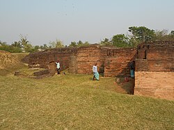 A part of the extensive structural complex
 -
 A narrow lane inside Ballal Dhipi complex
 -
 Partial views of Ballal Sen's Dhipi
 -
 A ruined part of Ballal Sen's Dhipi
 -
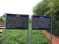 The information boards
 -
 An inscription in Ballal Dhipi
_20180728_111546.jpg)
-_20180728_111313.jpg)


_20180728_110902.jpg)


References
- ↑ "Mound known as Bamanpukur Mound of Fort". ASI, Kolkata Circle. Retrieved 18 October 2020.
- ↑ "Pilgrimages & Tourist Spots". Ballal Dhipi. Egiye Bangla, official website of Nadia district. Retrieved 18 October 2020.
- ↑ "List of Ancient Monuments and Archaeological Sites and Remains of West Bengal - Archaeological Survey of India". Item nos. 130&131. ASI. Retrieved 18 October 2020.