

>Rukumoni29 |
No edit summary |
||
| Line 10: | Line 10: | ||
[[File:Duncan Passage.svg|300px|thumb|Duncan Passage]] | [[File:Duncan Passage.svg|300px|thumb|Duncan Passage]] | ||
'''Duncan Passage''' is a [[strait]] in the [[ | '''Duncan Passage''' is a [[strait]] in the [[Bay of Bengal]]. It is about {{convert|48|km|abbr=on}} wide; it separates [[Rutland Island]] (part of [[Great Andaman]] and [[South Andaman]] administrative division) to the north, and [[Little Andaman]] to the south. West of Duncan Passage is the [[Bay of Bengal]]; east is the [[Andaman Sea]]. It lies within the [[exclusive economic zone of India]] protected by the integrated tri-services [[Andaman and Nicobar Command]] of [[Indian Military]]. | ||
It sits between [[The Sisters (Andaman and Nicobar Islands)|The Sisters]] island off [[South Andaman Island]] and [[North Brother Island (Andaman and Nicobar Islands)|North Brother Island]] off [[Little Andaman]] with a minimum depth of 21.9 m.<ref name=chan2>Prashant sharma,[https://books.google.com.sg/books?id=PlmxDQAAQBAJ&pg=PA8&lpg=PA8&dq=channel+between+India+and+sri+lanka&source=bl&ots=xShrmu0Xjf&sig=ACfU3U2G0ZXt9Yto7RMG68joq5qLOqUJWw&hl=en&sa=X&ved=2ahUKEwjMocXOlLjqAhWIb30KHerzBLsQ6AEwE3oECAgQAQ#v=onepage&q=channel%20between%20India%20and%20sri%20lanka&f=false Geography FAQ: for SSC, Bank PO, Railway, UPSC exams and CDS], page 8.</ref><ref name=stra7>2002, [https://books.google.com.sg/books?id=86ffAAAAMAAJ&pg=PA238&dq=Duncan+passage+depth&hl=en&sa=X&ved=2ahUKEwi2xKiwu7jqAhUKA3IKHaOkBI0Q6AEwAnoECAMQAg#v=onepage&q=Duncan%20passage%20depth&f=false Sailing Directions (enroute) for India and the Bay of Bengal]</ref> | It sits between [[The Sisters (Andaman and Nicobar Islands)|The Sisters]] island off [[South Andaman Island]] and [[North Brother Island (Andaman and Nicobar Islands)|North Brother Island]] off [[Little Andaman]] with a minimum depth of 21.9 m.<ref name=chan2>Prashant sharma,[https://books.google.com.sg/books?id=PlmxDQAAQBAJ&pg=PA8&lpg=PA8&dq=channel+between+India+and+sri+lanka&source=bl&ots=xShrmu0Xjf&sig=ACfU3U2G0ZXt9Yto7RMG68joq5qLOqUJWw&hl=en&sa=X&ved=2ahUKEwjMocXOlLjqAhWIb30KHerzBLsQ6AEwE3oECAgQAQ#v=onepage&q=channel%20between%20India%20and%20sri%20lanka&f=false Geography FAQ: for SSC, Bank PO, Railway, UPSC exams and CDS], page 8.</ref><ref name=stra7>2002, [https://books.google.com.sg/books?id=86ffAAAAMAAJ&pg=PA238&dq=Duncan+passage+depth&hl=en&sa=X&ved=2ahUKEwi2xKiwu7jqAhUKA3IKHaOkBI0Q6AEwAnoECAMQAg#v=onepage&q=Duncan%20passage%20depth&f=false Sailing Directions (enroute) for India and the Bay of Bengal]</ref> | ||
Latest revision as of 02:04, 2 June 2022
| Duncan Passage | |
|---|---|
  Duncan Passage Location in the Bay of Bengal. | |
| Coordinates | 11°2′N 92°35′E / 11.033°N 92.583°E |
| Type | Channel |
| Part of | Indian Ocean |

Duncan Passage is a strait in the Bay of Bengal. It is about 48 km (30 mi) wide; it separates Rutland Island (part of Great Andaman and South Andaman administrative division) to the north, and Little Andaman to the south. West of Duncan Passage is the Bay of Bengal; east is the Andaman Sea. It lies within the exclusive economic zone of India protected by the integrated tri-services Andaman and Nicobar Command of Indian Military.
It sits between The Sisters island off South Andaman Island and North Brother Island off Little Andaman with a minimum depth of 21.9 m.[1][2]
Manners Strait is the branch of Duncan Passage that lies between North Cinque Island and Rutland Island.
Islands along Duncan Passage[edit | edit source]
Several small islands and islets lie along the passage. North to south, they are:
- North Cinque Island
- South Cinque Island
- Passage Island
- The Sisters
- North Brother Island
- South Brother Island
Nearby major channels and straits[edit | edit source]
In Andamans[edit | edit source]
- Cocos Strait
- Ten Degree Channel
- Duncan Passage
- Six Degree Channel[3]
Outside Andaman[edit | edit source]
Gallery[edit | edit source]
-
 Gulf of Mannar
 -
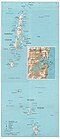 Cocos Strait, Duncan Passage
 -
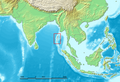 Cocos Strait is at the northern end of Andaman Islands in red square
 -
 Ten Degrees Channel
 -
 Ten Degrees Channel, closeup
 -
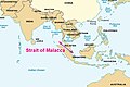 Malacca Strait
 -
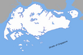 Singapore Strait
 -
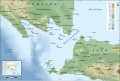 Sunda Strait
 -
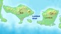 Lombok Strait
 -


References[edit | edit source]
- ↑ Prashant sharma,Geography FAQ: for SSC, Bank PO, Railway, UPSC exams and CDS, page 8.
- ↑ 2002, Sailing Directions (enroute) for India and the Bay of Bengal
- ↑ Mohor Chakraborty and Tridib Chakraborti, 2020, India's Strategy in the South China Seabooks.
- ↑ "СИНГАПУРСКИЙ ПРОЛИВ - это... Что такое СИНГАПУРСКИЙ ПРОЛИВ?". Словари и энциклопедии на Академике (in русский). Retrieved 2018-07-29.
- ↑ "Sunda Islands". Concise Dictionary of World Place-Names. John Everett-Heath. Oxford University Press 2005. Oxford Reference Online. Oxford University Press.
- ↑ Donald B. Freeman, The Straits of Malacca: Gateway Or Gauntlet?. McGill-Queen's Press, 2006.
- ↑ 7.0 7.1 The designaiton of routing measures in Sunda and Lombok Straits.
- ↑ Susanto, R. Dwi; Leonid Mitnik; Quanan Zheng (December 2005). "Ocean Internal Waves Observed in the Lombok Strait" (PDF). Oceanography. p. 83. Archived from the original (PDF) on 9 October 2011. Retrieved 16 May 2008.
- ↑ India’s Strategic Dimensions in Malacca Strait By Vithiyapathy Purushothaman, 16 March 2015.