

>Monkbot m Task 18 (cosmetic): eval 2 templates: hyphenate params (4×); |
m robot: Update article (please report if you notice any mistake or error in this edit) |
||
| Line 1: | Line 1: | ||
{{Short description|Fort in India}} | |||
{{Use dmy dates|date=July 2019}} | {{Use dmy dates|date=July 2019}} | ||
{{Infobox military installation | {{Infobox military installation | ||
| Line 4: | Line 5: | ||
|partof = | |partof = | ||
|location = [[Chandrapur district]], [[Maharashtra]] | |location = [[Chandrapur district]], [[Maharashtra]] | ||
|caption = Fort entrance | |caption = Fort entrance | ||
|map_type=India Maharashtra#India | |map_type=India Maharashtra#India | ||
| Line 46: | Line 46: | ||
The Queen's palace is situated near a small dam with steps and a few rooms for bathing. Two wooden pagodas were constructed by the Forest Department. The fort area is filled with shrubs and trees.<ref>https://cultural.maharashtra.gov.in/english/gazetteer/CHANDRAPUR/places_Manikgad.html</ref> | The Queen's palace is situated near a small dam with steps and a few rooms for bathing. Two wooden pagodas were constructed by the Forest Department. The fort area is filled with shrubs and trees.<ref>https://cultural.maharashtra.gov.in/english/gazetteer/CHANDRAPUR/places_Manikgad.html</ref> | ||
{{clear}} | {{clear}} | ||
==Gallery== | ==Gallery== | ||
<gallery mode="packed"> | <gallery mode="packed"> | ||
| Line 57: | Line 58: | ||
== References == | == References == | ||
{{ | {{commons category|Manikgad Fort}} | ||
{{reflist}} | {{reflist}} | ||
Revision as of 17:33, 1 July 2022
| Manikgad Fort | |
|---|---|
| Chandrapur district, Maharashtra | |
  Manikgad Fort  Manikgad Fort | |
| Coordinates | 19°40′30.6″N 79°07′31.5″E / 19.675167°N 79.125417°E |
| Type | Hill fort |
| Height | 507 MTRS |
| Site information | |
| Owner | Government of India |
| Controlled by |  Maratha (1739-1818) Maratha (1739-1818) United Kingdom United Kingdom
|
| Open to the public | Yes |
| Condition | Ruins |
| Site history | |
| Built by | Naga king-Gahilu |
| Materials | Stone |


Manikgad / (also called Gadchandur) (Marathi: माणिकगड / गडचांदूर) is an ancient fort in Chandrapur district, Maharashtra. It is a hill fort 507 metres above sea level built by the Naga kings in 9 CE.[1] The fort is in ruins and is frequented by wild animals that live in the vicinity, such as panthers and boars. Several monuments of historical importance are nearby.[2]
History
Manikgad was built by the last Mana Naga King - Gahilu. The Mana Nagas settled in this area around 9 CE. Initially, the fort was named Manikagad after the patron deity of the Mana Nagas - Manikadevi - but later on this was shortened to Manikgad.
Local legend holds that the fort was built by a Gond king named Mankyal (hence the name Manikgad). However, the lintel of the entrance gate has a Naga image carved in relief and not the Gond emblem of a lion and an elephant. So this legend is likely not true.[2]
Features
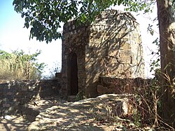
The fort was built of large black stones and was a formidable defense in its time. Rampart walls of the fort enclose a valley that has ruins of old buildings and store-houses. Outlines of apartments are visible against the rampart walls. The southern bastion, along with its supporting wall, collapsed.
In the valley below lies a cannon that likely was mounted on that bastion. Unlike a cast-iron cannon, this cannon is made of several iron straps welded together. The gateway of the fort is intact.[2]
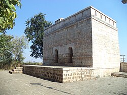
The Queen's palace is situated near a small dam with steps and a few rooms for bathing. Two wooden pagodas were constructed by the Forest Department. The fort area is filled with shrubs and trees.[3]
Gallery
-
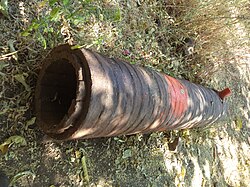 A Cannon
 -
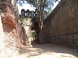 The Second gate
 -
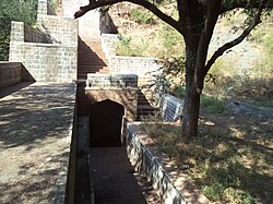 The Queens palace
 -
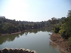 The Lake
 -
 A Bastion
 -
 The Observation tower


References
- ↑ "Friends of Forts". Archived from the original on 5 April 2009. Retrieved 1 February 2009.
- ↑ 2.0 2.1 2.2 "Chandrapur District Gazetteer". Government of Maharashtra. Retrieved 10 April 2009.
- ↑ https://cultural.maharashtra.gov.in/english/gazetteer/CHANDRAPUR/places_Manikgad.html
 | This article about an Indian building or structure is a stub. You can help Bharatpedia by expanding it. |