

robot: Update article (please report if you notice any mistake or error in this edit) |
m adjust citations after review and improved wording after review |
||
| Line 1: | Line 1: | ||
{{Short description|Archaeological site in West Bengal}} | {{Short description|Archaeological site in West Bengal}} | ||
{{Use dmy dates|date=January 2023}} | |||
{{Use Indian English|date=January 2023}} | |||
{{Infobox ancient site | {{Infobox ancient site | ||
|name = Ballal Dhipi | |name = Ballal Dhipi | ||
| Line 104: | Line 106: | ||
===Excavations=== | ===Excavations=== | ||
The Kolkata Circle of the [[Archaeological Survey of India]] excavated the mound, during 1982-1988, and | The Kolkata Circle of the [[Archaeological Survey of India]] excavated the mound, during 1982-1988, and "exposed huge brick structures and various antiquities datable to c. 10th to 12th cent. AD. The brick structure include shrines on sides and a massive construction within an enclosure." The antiquities indicate the possibility of Buddhist affiliation. The structural complex covers nearly 13,000 m<sup>2</sup>. Experts opine the "stupa(vihara) of eighth/ ninth century was perhaps a seat of learning and pilgrimage up to the end of the 11th century." It is about 25 km from [[Krishnanagar, Nadia|Krishnanagar]].<ref>{{cite web | url = https://www.asikolkata.in/nadia.aspx | title = Mound known as Bamanpukur Mound of Fort | publisher = ASI, Kolkata Circle | accessdate = 18 October 2020}}</ref><ref>{{cite web | url = http://www.nadia.nic.in/Tourism-Details/tourism-details.html | title = Pilgrimages & Tourist Spots| work = Ballal Dhipi| publisher = Egiye Bangla, official website of Nadia district | accessdate = 18 October 2020}}</ref> | ||
The ASI has divided the site into two parts – the mound and the remains of a fort. Both the sites are identified as an [[List of Monuments of National Importance in West Bengal|ASI listed monument]].<ref>{{Cite web|url=http://asi.nic.in/alphabetical-list-of-monuments-west-bengal/|title=List of Ancient Monuments and Archaeological Sites and Remains of West Bengal - Archaeological Survey of India|publisher= ASI|work= Item nos. 130&131|access-date=18 October 2020}}</ref> | The ASI has divided the site into two parts – the mound and the remains of a fort. Both the sites are identified as an [[List of Monuments of National Importance in West Bengal|ASI listed monument]].<ref>{{Cite web|url=http://asi.nic.in/alphabetical-list-of-monuments-west-bengal/|title=List of Ancient Monuments and Archaeological Sites and Remains of West Bengal - Archaeological Survey of India|publisher= ASI|work= Item nos. 130&131|access-date=18 October 2020}}</ref><ref name="Rangan">{{cite news |last1=Datta |first1=Rangan |title=Ballal Dhipi near Mayapur — a perfect (and mysterious) destination for a day outing |url=https://www.telegraphindia.com/my-kolkata/places/ballal-dhipi-near-mayapur-a-perfect-destination-for-winter-day-outing/cid/1910416 |access-date=3 October 2023 |agency=My Kolkata |publisher=The Telegraph}}</ref> | ||
==Ballal Dhipi picture gallery== | ==Ballal Dhipi picture gallery== | ||
| Line 117: | Line 119: | ||
File:Ballal Sen's Dhipi at Bamunpukur, Nadia 12.jpg|A ruined part of Ballal Sen's Dhipi | File:Ballal Sen's Dhipi at Bamunpukur, Nadia 12.jpg|A ruined part of Ballal Sen's Dhipi | ||
File:Mound known as Bahanpukur Mound or Fort (Ballal dibi) 20180728 110902.jpg|The information boards | File:Mound known as Bahanpukur Mound or Fort (Ballal dibi) 20180728 110902.jpg|The information boards | ||
File:Ballal Sen's Dhipi at Bamunpukur, Nadia 06.jpg| | File:Ballal Sen's Dhipi at Bamunpukur, Nadia 06.jpg|A crocodile head-shaped water outlet at Ballal Dhipi | ||
</gallery> | </gallery> | ||
Latest revision as of 04:30, 13 August 2025
 Ballal Dhipi ruins | |
Shown within West Bengal   Ballal Dhipi (India) | |
| Location | Bamanpukur, Nadia district |
|---|---|
| Region | West Bengal, India |
| Coordinates | 23°27′01″N 88°24′05″E / 23.4503°N 88.4014°E |
| Type | Buddhist Vihara |
| History | |
| Founded | 10-12th century or a little earlier |
Ballal Dhipi is a historic archeological site on the eastern flood plain of the Hooghly in Nadia, West Bengal, a few kilometres east of Nabadwip. The remains date back to the 12th century AD and earlier. A 30-ft structure of solid terracotta bricks is spread over an area of 1,300 sq ft. with a floor made of lime and sand. It is named after Ballala Sena (1160-1179) of the Sena dynasty.
Archaeologists have found traces of a temple complex. Historians differ on the origin of the structure. It may be the ruin of a Buddhist stupa or vihar, possibly built between the 11th and 13th centuries. It has similarities with Vikramshila Vihar, in Bihar and Shompur Vihar, in Rajshahi, Bangladesh. It may also be a part of the capital of the Sena dynasty.
Geography[edit | edit source]
Lua error in Module:OSM_Location_map at line 1984: attempt to index field 'wikibase' (a nil value).
Location[edit | edit source]
Ballal Dhipi is located at Bamunpukur, near Mayapur and Nabadwip, 23°27′01″N 88°24′05″E / 23.4503°N 88.4014°E.
Note: The map alongside presents some of the notable locations in the subdivision. All places marked in the map are linked in the larger full screen map.
Excavations[edit | edit source]
The Kolkata Circle of the Archaeological Survey of India excavated the mound, during 1982-1988, and "exposed huge brick structures and various antiquities datable to c. 10th to 12th cent. AD. The brick structure include shrines on sides and a massive construction within an enclosure." The antiquities indicate the possibility of Buddhist affiliation. The structural complex covers nearly 13,000 m2. Experts opine the "stupa(vihara) of eighth/ ninth century was perhaps a seat of learning and pilgrimage up to the end of the 11th century." It is about 25 km from Krishnanagar.[1][2]
The ASI has divided the site into two parts – the mound and the remains of a fort. Both the sites are identified as an ASI listed monument.[3][4]
Ballal Dhipi picture gallery[edit | edit source]
-
 It is thought to be the remains of a fort
 -
 The remains of a staircase
 -
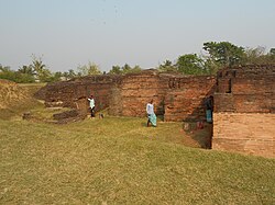 A part of the extensive structural complex
 -
 A narrow lane inside Ballal Dhipi complex
 -
 Partial views of Ballal Sen's Dhipi
 -
 A ruined part of Ballal Sen's Dhipi
 -
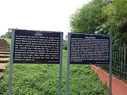 The information boards
 -
 A crocodile head-shaped water outlet at Ballal Dhipi
_20180728_111546.jpg)
-_20180728_111313.jpg)


_20180728_110902.jpg)


References[edit | edit source]
- ↑ "Mound known as Bamanpukur Mound of Fort". ASI, Kolkata Circle. Retrieved 18 October 2020.
- ↑ "Pilgrimages & Tourist Spots". Ballal Dhipi. Egiye Bangla, official website of Nadia district. Retrieved 18 October 2020.
- ↑ "List of Ancient Monuments and Archaeological Sites and Remains of West Bengal - Archaeological Survey of India". Item nos. 130&131. ASI. Retrieved 18 October 2020.
- ↑ Datta, Rangan. "Ballal Dhipi near Mayapur — a perfect (and mysterious) destination for a day outing". The Telegraph. My Kolkata. Retrieved 3 October 2023.