.svg)
Markanda River (Haryana)
 Thank you for being part of the Bharatpedia family! 0% transparency: ₹0 raised out of ₹100,000 (0 supporter) |
| Markanda River | |
|---|---|
 | |
| Native name | मारकंडा नदी (Hindi) |
| Location | |
| Country | India |
| Physical characteristics | |
| Source | |
| • location | Near Katasan Devi Temple, Baraban, Sirmaur District, Himachal Pradesh |
| Mouth | Ghaggar River |
• location | Himachal Pradesh, India |
• coordinates | 30°05′26″N 76°23′39″E / 30.0905°N 76.3943°ECoordinates: 30°05′26″N 76°23′39″E / 30.0905°N 76.3943°E |
| Length | 90 km (56 mi) |
| Basin features | |
| Tributaries | |
| • left | Begna river, Ran, nakati |
| Waterbodies | Jalbehra barrage in Kurukshetra |
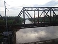
| Bridges | Markanda Bridge, Haryana |
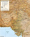
The Markanda (Hindi: मारकंडा नदी) is a river in the Indian states of Himachal Pradesh and Haryana. It is a tributary of the Ghaggar river, flowing through Sirmaur District, Ambala district and Shahabad Markanda, a town in Kurukshetra district.[1][2] The Markanda river's ancient name was Aruna.
Origin and route[edit]
The Markanda river is an eponymous seasonal river in Haryana state, which is a main tributary of the Ghaggar River.[3]
The Markanda river originates in the Shivalik hills on the border of Haryana and Himachal Pradesh State, and flows along the haryana and Punjab, India border before meeting with Ghaggar river at the confluence.[4]
The basin is classified in two parts, Khadir and Bangar, the higher area that is not flooded in rainy season is called Bangar and the lower flood-prone area is called Khadar.[4]
Several archaeologists identify the old Ghaggar-Hakra River as the Sarasvati river, on the banks of which the Indus Valley civilisation developed.[5][6][7][8]
Gallery[edit]
Indus–Sarasvati civilisation major sites
Ghaggar river flowing through Panchkula in Haryana
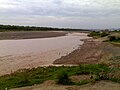
Markanda River at Markanda, Haryana


See also[edit]
- Dangri, a tributary of Sarsuti
- Tangri river, a tributary of Sarsuti, merge if Dangri and Tangri are same
- Sarsuti, a tributary of Ghaggar-Hakra River
- Kaushalya river, a tributary of Ghaggar-Hakra River
- Chautang, a tributary of Ghaggar-Hakra River
- Sutlej, a tributary of Indus
- Ganges
- Indus
- Western Yamuna Canal, branches off Yamuna
References[edit]
- ↑ AmbalaOnline - Rrvers of Ambala
- ↑ Chopra, Sanjeev (25 September 2010). "Overflowing Ghaggar, Tangri inundate some villages along Punjab-Haryana border". The Indian Express. Retrieved 9 April 2017.
- ↑ Shanker Sharma, Hari; Kalwar, S. C. (2005). Geomorphology and Environmental Sustainability: Felicitation Volume in Honour of Professor H.S. Sharma. Concept Publishing Company. p. 61. ISBN 978-81-8069-028-0.
- ↑ 4.0 4.1 HaryanaOnline - Geography of Haryana Archived 1 February 2016 at the Wayback Machine
- ↑ Possehl, Gregory L. (December 1997), "The Transformation of the Indus Civilization", Journal of World Prehistory, 11 (4): 425–472, doi:10.1007/bf02220556, JSTOR 25801118, S2CID 161129625
- ↑ Kenoyer, J. M. (1997), "Early City-states in South Asia: Comparing the Harappan Phase and the Early Historic Period", in D. L. Nichols; T. H. Charlton (eds.), The Archaeology of City States: Cross Cultural Approaches, Washington: Smithsonian Institution, pp. 52–70, ISBN 1560987227
- ↑ Allchin, Bridget; Allchin, Raymond (1982), The Rise of Civilization in India and Pakistan, Cambridge University Press, p. 160, ISBN 978-0-521-28550-6
- ↑ Erdosy 1995, p. 44.
External links[edit]
- Sarasvati-Sindhu civilization and Sarasvati River
- The Saraswati: Where lies the mystery by Saswati Paik
| Rivers | |
|---|---|
| Lakes |
|
| Dams, Barrages | |