Lanak La
 Thank you for being part of the Bharatpedia family! 0% transparency: ₹0 raised out of ₹100,000 (0 supporter) |
Template:Infobox mountain pass
| Lanak La |
|---|
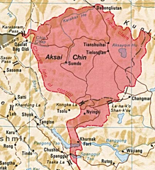
Lanak La (Tibetan: ལ་ནག་ལ; transliteration: Lanag La) or Lanak Pass (Chinese: 拉那克山口; pinyin: Lā nà kè shānkǒu; Hindi: लानक दर्रा) is a mountain pass in the disputed Aksai Chin region, administered by China as part of the Tibet Autonomous Region. It is claimed by India as its border pass.
HistoryEdit

Lanak La had been a well-established frontier point between Ladakh and Tibet, as confirmed by travellers from William Moorcroft in 1820 onwards.[2] Several travellers wrote in the late 19th and early 20th centuries that the traditional boundary between India and Tibet was at Lanak La. They also state that the border was accepted by both sides.[3][4][5][6][7][8][9][10]
There are substantial Kashmiri Government records for the area of the Chang Chenmo valley up to the Lanak pass. In addition to the revenue records, 1908 Ladakh Settlement Report, reports of several survey teams, the Jammu and Kashmir Game Preservation Act of 1951, there are Kashmiri documents relating to the construction and maintenance of trade routes, rest houses, and storehouses in the Chang Chenmo valley. All of them placed the entire valley up to the Lanak Pass within Ladakh.[11]
Chinese claimsEdit


Chinese maps also recognised Lanak La as the boundary till 1951.[12] In 1956, the People's Republic of China published what appears to be its first self-defined map, in which Kongka Pass was marked as the boundary.
There was no Chinese presence in the area of Lanak La till June 1958, when an Indian patrol party had gone up to it along the Changchenmo Valley.[13][14] There was an Indian flag planted there until 1956.[15][16]
In the following year, Chinese troops had infiltrated into the Changchenmo Valley. In October 1959, as an Indian border patrol party was attempting to set up posts in the vicinity of the Kongka Pass,[17][18] they were ambushed by Chinese troops, killing some of them and taking others prisoner.[18]
Some western scholars such as Larry Wortzel and Allen S. Whiting appear to endorse the Chinese claim that Kongka Pass was the "traditional" boundary of Tibet.[19][20] Other scholars however point out the Chinese inconsistencies.[21][22]
Historical mapsEdit
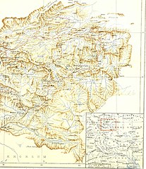
Map by Cecil Rawling, showing Lanak La on the boundary in inset map (1905)
Map including Lanak La (Stanford, 1917)
Map including Lanak La (DMA, 1989)
Map including Lanak La (labeled as La-na-k'o Shan-k'ou, CIA, 2013)
_(14776461552).jpg)
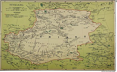
_p61_PLATE19._SINKIANG_(14597194848).jpg)


See alsoEdit
ReferencesEdit
- ↑ Drew, Frederic (1875), The Jummoo and Kashmir Territories: A Geographical Account, E. Stanford – via archive.org
- ↑ Richardson, H. E. (1962). A Short History of Tibet. E. P. Dutton. p. 225.[dead link][ISBN missing]
- ↑ Wellby, M.S. (1898). Through Unknown Tibet. Lippincott. p. 78. ISBN 9788120610583.
- ↑ Carey, A. D. (1887). "A Journey round Chinese Turkistan and along the Northern frontier of Tibet". Proceedings of the Royal Geographic Society. 9 (12): 731–752. doi:10.2307/1801130. JSTOR 1801130.
- ↑ Bower, Hamilton, Diary of A Journey across Tibet, London, 1894
- ↑ Rawling, C. G., The Great Plateau Being An Account Of Exploration In Central Tibet, 1903, And Of The Gartok Expedition 1904-1905, p 38, London, 1905
- ↑ Deasy, H. H. P. (August 1900). "Journeys in Central Asia". The Geographical Journal. 6 (2): 142. JSTOR 1774554.
- ↑ Bruce, C. D. (June 1907). "A Journey across Asia from Leh to Peking". The Geographical Journal. 29 (6): 600. doi:10.2307/1776269. JSTOR 1776269.
- ↑ "Report of the Officials of the Governments of India and the People's Republic of China on the Boundary Question - Part 2" (PDF). Ministry of External Affairs, India, 1961. Archived from the original (PDF) on 21 September 2013. Retrieved 30 August 2013.
- ↑ Verma, Virendra Sahai (2006). "Sino-Indian Border Dispute At Aksai Chin - A Middle Path For Resolution" (PDF). Journal of Development Alternatives and Area Studies. 25 (3): 6–8. ISSN 1651-9728. Retrieved 30 August 2013.
- ↑ Fisher, Rose & Huttenback, Himalayan Battleground (1963), p. 112
- ↑ Karackattu, Joe Thomas (2020). "The Corrosive Compromise of the Sino-Indian Border Management Framework: From Doklam to Galwan". Asian Affairs. 51 (3): 590–604. doi:10.1080/03068374.2020.1804726. S2CID 222093756.
- ↑ Hoffmann, India and the China Crisis (1990), p. 77: "This company was commanded by the most experienced Indian patrol leader in Ladakh, one Karam Singh, who (the previous June) had taken a patrol through Hot Spring, Kongka Pass, and then forty miles further to Lanak La. No sign of a Chinese presence had been seen then..."
- ↑ Mullik, B. N. (1971), My Years with Nehru: The Chinese Betrayal, Allied Publishers, p. 627
- ↑ Hudson, Geoffrey Francis (1963). Far Eastern Affairs, Volume 3. St. Martin's Press. p. 20.
- ↑ "Notes, Memoranda and letters Exchanged and Agreements signed between The Governments of India and China - White Paper VIII" (PDF). Archived from the original (PDF) on 21 September 2013. Retrieved 30 August 2013.
- ↑ Hoffmann, India and the China Crisis (1990), p. 77: "It happened two miles west of the pass, on the banks of the Chang Chenmo River." (emphasis added)
- ↑ 18.0 18.1 Maxwell, Neville (1970). India's China War. New York: Pantheon. p. 13.
- ↑ Wortzel, Larry (2003). Burkitt, Laurie; Scobell, Andrew; Wortzel, Larry (eds.). The Lessons of History: The Chinese People's Liberation Army at 75 (PDF). Strategic Studies Institute, U.S. Army War College. p. 331. ISBN 9781428916517.
- ↑ Whiting, Allen S. (1987). "The Sino-Soviet Split". In MacFarquhar, Roderick; Fairbank, John K. (eds.). The Cambridge History of China, Volume 14. Cambridge University Press. p. 512. ISBN 978-0-521-24336-0.
- ↑ Fisher, Rose & Huttenback, Himalayan Battleground (1963), p. 101: "Confusion as to the extent of the Chang Chenmo valley between the Lanak and Kongka passes continued to be a feature of Chinese cartography even after the Communists came to power.... the flexibility shown by official Chinese cartographers here and on other sections of the border makes mockery of China's oft-repeated claim that its concept of the border has a solid basis in history."
- ↑
Van Eekelen, Willem Frederik (1967), Indian Foreign Policy and the Border Dispute with China, Springer, p. 164, ISBN 978-94-017-6555-8,
The Chinese could not quote a single document confirming that the Kongka Pass constituted the boundary.... The thorough approach of the Indian side generally contrasted with an inconsistent and almost careless presentation by the Chinese officials.
BibliographyEdit
- Fisher, Margaret W.; Rose, Leo E.; Huttenback, Robert A. (1963), Himalayan Battleground: Sino-Indian Rivalry in Ladakh, Praeger – via archive.org