.svg)
Hormuz Island
 Thank you for being part of the Bharatpedia family! 0% transparency: ₹0 raised out of ₹100,000 (0 supporter) |
This article includes a list of references, related reading or external links, but its sources remain unclear because it lacks inline citations. (February 2022) |
Hormuz Island | |
|---|---|
Island | |
 Satellite photo of Hormuz Island | |
| Lua error in Module:Mapframe at line 764: attempt to index field 'wikibase' (a nil value). | |
| Lua error in Module:Location_map at line 501: Unable to find the specified location map definition: "Module:Location map/data/Iran" does not exist. | |
| Coordinates: 27°04′03″N 56°27′36″E / 27.06750°N 56.46000°ECoordinates: 27°04′03″N 56°27′36″E / 27.06750°N 56.46000°E | |
| Country | |
| Province | Hormozgān |
| Area | |
| • Land | 42 km2 (16.2 sq mi) |
| Elevation | 186 m (610 ft) |
| Time zone | UTC+3:30 (IRST) |


Hormuz Island (/hɔːrˈmuːz/; Persian: جزیره هرمز Jazireh-ye Hormoz), also spelled Hormoz, is an Iranian island in the Persian Gulf. Located in the Strait of Hormuz, 8 km (5 mi) off the Iranian coast, the island is part of Hormozgan Province. It is sparsely inhabited, but some development has taken place since the late 20th century.
History[edit]
The earliest evidence for human presence on the island is several stone artifacts discovered at the eastern shorelines of the island. A lithic scatter was found at a site called Chand-Derakht, which is an uplifted marine Pleistocene terrace. This site yielded a Middle Paleolithic lithic assemblage characterized by Levallois methods and dates back to more than 40,000 years ago.[1]
The island, known as Organa (Όργανα) to the ancient Greeks and as Jarun in the Islamic period, acquired the name of "Hormuz" from the important harbour town of Hormuz (Ormus) on the mainland 60 km away, which had been a centre of a minor principality on both sides of the strait. The principality paid tribute to the Mongol-ruled Ilkhanate and was an important source of income from maritime trade.[2] The town's ruler decided to shift his residence to the island around 1300, in order to evade attacks by Mongolian and Turkish groups from the interior.[3] The ruler later made peace with the Ilkhans.
A new town was built on the northern tip of Jarun island which was called New Hormuz for a number of years to distinguish it from the old town on the mainland until this fell into ruins. Slowly the name of the new town came to be used for the island as well.
The island is arid, and during the summer months, the temperature can rise to over 43 °C (109 °F). As such, it was not an ideal location for the capital of a principality as all provisions including water had to be brought from the mainland. Its location, however, gave the island a degree of security which let it grow to be a major trading port for several centuries. As its competitors suffered from intermittent destruction, Hormuz remained a reliable and relatively safe harborage.
Hormuz was visited by Marco Polo, around 1290, while traveling by land, as described in his travelogue.
Ibn Battuta also visited the island and New Hormuz.[4]

In 1505, King Manuel I of Portugal established a policy of expansion in Africa and Western Asia. During attempts to expand Portuguese influence into the Indian Ocean, the Portuguese duke Afonso de Albuquerque captured the island in 1507 and it was incorporated into the greater Portuguese Empire. The Portuguese constructed a fortress on the island to deter potential invaders, naming it the Fort of Our Lady of the Conception. The island became an emergency stopover point for Portuguese ships traveling to Goa, Gujarat, and nearby Kishm. The Ottomans laid siege to the island under the admiral and cartographer Piri Reis in 1552.[5] In 1622, the island was captured from the Portuguese by a combined Anglo-Persian force at the behest of the English East India Company.
Shah Abbas I of Persia distrusted the local population and was not interested in maintaining the island as a trading centre or military post; instead he developed the nearby mainland port of Bandar Abbas. Hormuz went into decline. Many of its inhabitants seasonally moved to their fields and orchards around the old Hormuz on the mainland, only fishermen being in permanent residence. The island continued to export small quantities of rock salt and lumps of iron oxide which were used as ballast stones for sailing ships.[6]
After a period of Omani administration in the 19th century, it remained a sparsely inhabited fishermen's island before experiencing some development in the later years of the 20th century.
Geography and geology[edit]
Hormuz Island has an area of 42 km2 (16 sq mi). It is covered by sedimentary rock and layers of volcanic material on its surface. The highest point of the island is about 186 m (610 ft) above sea level. Due to a lack of precipitation, the soil and water are salty. Specialists have helped cultivar white mangrove or Hara trees to grow in the climate. Due to the lack of fresh water, Iranian engineers have constructed a water pipeline from the mainland. There are many beaches that go all around the island.[citation needed]
Reddish ochre on the island and its beaches, called Golak by natives, has been exploited for artistic and culinary purposes, and also attracts tourists. Degradation due to overuse of the ochre has resulted in actions by the Department of Environment to protect it.[7]
The satellite images catching the concentric arrangement of the rocks show that Hormuz Island appears to be a so called salt diapir, composed of ancient seasalt deposists which due to lack of salt dissolving groundwater and rains and due to their plastic deformabilty can flow and squeeze just like ice and thus under the squeezing pressure of other sediments on top has managed to rise above the surface over many many thousands of years, and during that time has been eroded into different shapes. The geological age of the Hormuz island is about 600 million years, and its life out of the water is about 50 thousand years.[8]
Attractions[edit]
Statues Valley[edit]
With a few hundred meters walk to the beach, in a way that silver sands attracts attention, rocks can be seen in many different forms, each is likened to an animal, a sheep's head, poultry and many different Dragons.[citation needed]
Red Beach[edit]
Hormuz Island has soil rich in red ferrious oxide soil, called “Gelack”. It is a valuable mineral for industrial purposes, and it used as a spice in local cuisine, such as sauces and jams.
The mountain being on the shoreline, makes the red beach and red sea waves an unusual sight. Visitors walking along the shore will encounter areas where sand glitters with metal compounds.[9]
Mangrove forest[edit]
Hormuz island has a forest of mangrove trees. The waterways and wild birds with its pristine nature attracts many tourists. Sea Forest has trees that live in the saltwater tidal area. Sometime most of them submerge in the sea water, but continue to survive. Iran’s southern coast is known for its aridity and salty sea water. there is a grassy area, that grows without the need for fresh water. In a story this mythical plant is grown from Adam’s tears.[10]
Dr. Nadalian Museum[edit]

The Museum of Dr Nadalian in Hormuz Island, also known as the Museum and Gallery of Ahmad Nadalian in Hormuz Island, shows the work of Ahmad Nadalian (born 1963[11]), whose works have been shown in galleries internationally.[12] His environmental art projects include rock carvings, and not only his work, but also that of local indigenous women, bones of sea creatures are displayed in his museum,[13] and dolls made of recycled materials.[14]
The museum was created in March 2009 as the Paradise Art Centre, being renamed in 2012 to its current name. Also at this time, its entrance was redesigned with inspiration from local architecture.[15]
Gallery[edit]

Hormuz Island beach
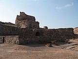
The Fort of Our Lady of the Conception, Hormuz Island

Hara forests at Hormuz Island

The sea cliffs near the Valley of Statues of Hormuz Island

Art made from ochre on the islands beaches


.jpg)


References[edit]
- ↑ Zarei, Sepehr, (2021) The First Evidence of the Pleistocene Occupation in the Hormuz Island: A Preliminary Report, Bulletin of Miho Museum 21:101-110.
- ↑ Cambridge history of India, vol. 1, p.147
- ↑ H. Yule, The Book of Ser Marco Polo, 1903, vol. I, p. 110, quoting Abulfeda ("Hormuz was devastated by the incursions of the Tartars, and its people transferred their abode to an island in the sea called Zarun, near the continent, lying west of the old city.") and Odoric for the date.
- ↑ Battutah, Ibn (2002). The Travels of Ibn Battutah. London: Picador. pp. 98–99, 308. ISBN 9780330418799.
- ↑ Pîrî Reis’in Hürmüz Seferi ve İdamı Hakkındaki Türk ve Portekiz Tarihçilerinin Düşünceleri Archived 2012-12-02 at the Wayback Machine Ertuğrul Önalp. Prof. Dr. Ankara Üniversitesi, Dil ve Tarih-Coğrafya Fakültesi, İspanyol Dili ve Edebiyatı Anabilim Dalı. (in Turkish)
- ↑ "HORMUZ ii. ISLAMIC PERIOD – Encyclopaedia Iranica". www.iranicaonline.org. Archived from the original on May 20, 2020. Retrieved Mar 31, 2020.
- ↑ Hormuz, the rainbow island of Iran Archived 2020-03-28 at the Wayback Machine. Tehran Times (2017-10-14). Retrieved 2020-03-28.
- ↑ "دره مجسمه ها Statues Valley". هتل جزیره هرمز &#; Hotel in Hormuz island. Archived from the original on August 12, 2020. Retrieved Mar 31, 2020.
- ↑ [/ "Hormuz island red beach"]. هتل جزیره هرمز &#; Hotel in Hormuz island. Archived from the original on August 12, 2020. Retrieved Mar 31, 2020.
{{cite web}}: Check|url=value (help) - ↑ "جنگل حرا mongrove forest". هتل جزیره هرمز &#; Hotel in Hormuz island. Archived from the original on August 12, 2020. Retrieved Mar 31, 2022.
- ↑ "About". Dr. Nadalian. 31 August 2021. Archived from the original on 14 February 2022. Retrieved 14 February 2022.
- ↑ "The Museum and Gallery of Dr. Ahamd Nadalian in Hormuz Island". Dr. Nadalian. 30 September 2021. Archived from the original on 14 February 2022. Retrieved 14 February 2022.
- ↑ "The Museum of Dr. Ahmad Nadalian in Hormuz". alaedin.travel (in Latina). Archived from the original on 14 February 2022. Retrieved 14 February 2022.
- ↑ Rasaneh, Sirang (12 June 1906). "Dr. Ahmad Nadalian Museum & Gallery 2022 Tourist Attraction in Hormoz Island". Iran Tourism & Touring. Archived from the original on 14 February 2022. Retrieved 14 February 2022.
- ↑ "WWW.RiverArt.Net- Environmental Works by A. Nadalian هنر رودخانه: آثار دكتر احمد نادعليان". www.riverart.net. Archived from the original on March 1, 2020. Retrieved Mar 31, 2020.
Sources[edit]
- .الكوخردى ، محمد ، بن يوسف، (كُوخِرد حَاضِرَة اِسلامِيةَ عَلي ضِفافِ نَهر مِهران) الطبعة الثالثة ،دبى: سنة 199۷ للميلاد Mohammed Kookherdi (1997) Kookherd, an Islamic civil at Mehran river, third edition: Dubai
- . کامله،القاسمی، بنت شیخ عبدالله، (تاریخ لنجة) مکتبة دبي للتوزیع، الامارات: الطبعة الثانية عام ۱۹۹۳ للمیلاد
- . الوحیدی الخنجی، حسین بن علی بن احمد، «تاریخ لنجه» ، الطبعة الثانية دبی: دار الأمة للنشر والتوزیع، ۱۹۸۸ للمیلاد
- . اطلس گیتاشناسی استانهای ایران Gitashenasi Province Atlas of Iran Atlas Gitashenasi Ostanhai Iran Template:Dead
- . دره مجسمه ها Statue Valley Hormuz Island Archived 2019-08-13 at the Wayback Machine
Further reading[edit]
- Speak the Wind (Mack, 2021; photographs by Hoda Afshar; essay by Michael Taussig[1]) This work documents the landscapes and people of the islands of Hormuz Island, Qeshm, and Hengam, in the Persian Gulf off the south coast of Iran.[2][3] Afshar got to know some of the people there, travelling there frequently over the years, and they told her about the history of the place. She said that "their narrations led the project", and she explores "the idea of being possessed by history, and in this context, the history of slavery and cruelty”.[4]
External links[edit]
- Hormuz, The Bloody Island of Iran The Globetrotting Detective.
Template:Hormozgan Province Template:Iranian islands in the Persian Gulf
- ↑ Afshar, Hoda; Taussig, Michael (2021). Speak the Wind. Photographs by Hoda Afhsar; essay by Michael Taussig. London: Mack. ISBN 978-1-913620-18-9.
- ↑ Boetker-Smith, Daniel; Afshar, Hoda. "Speak the Wind - Book review". LensCulture. Photographs by Hoda Afshar. Archived from the original on 14 February 2022. Retrieved 14 February 2022.
- ↑ Colberg, Jörg (16 August 2021). "Speak The Wind". Conscientious Photography Magazine. Archived from the original on 14 February 2022. Retrieved 14 February 2022.
- ↑ Grieve, Michael (19 July 2021). "Hoda Afshar captures the wind and rituals of the islands in the Strait of Hormuz". 1854 Photography. Archived from the original on 14 February 2022. Retrieved 14 February 2022.